IMAGES TAKEN NEAR TO
Leaford Avenue, MANCHESTER, M34 3QE
Introduction
This page details the photographs taken nearby to Leaford Avenue, M34 3QE by members of the Geograph project.
The Geograph project started in 2005 with the aim of publishing, organising and preserving representative images for every square kilometre of Great Britain, Ireland and the Isle of Man.

There are currently over 7.5m images from over14,400 individuals and you can help contribute to the project by visiting https://www.geograph.org.uk
Image Map
Images are licensed for reuse under creativecommons.org/licenses/by-sa/2.0
Notes
- Clicking on the map will re-center to the selected point.
- The higher the marker number, the further away the image location is from the centre of the postcode.
Image Listing (82 Images Found)
Images are licensed for reuse under creativecommons.org/licenses/by-sa/2.0
Image
Details
Distance
1
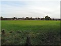
Queenie's Field
A recreation ground off Mansfield Avenue, named after Queeni, a horse that lived on the field.
Image: © Gerald England
Taken: 28 Oct 2010
0.05 miles
2
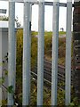
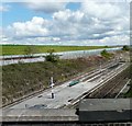
Looking over the line
From the end of a footbridge looking over the Guide Bridge to Stockport railway line towards the end of the Audenshaw reservoirs towards the tower known as Denton Rock Image
Image: © Gerald England
Taken: 28 Oct 2010
0.06 miles
3
Footbridge over the Railway
A footbridge over the Guide Bridge to Stockport railway line near Audenshaw Reservoirs.
Image: © Gerald England
Taken: 28 Oct 2010
0.07 miles
4
Path
Bridge carrying a path over the railway.
Image: © Peter McDermott
Taken: 18 Jun 2020
0.07 miles
5
Railway lines North from Denton
Railway lines beyond the end of the platform at Denton Station.
Image: © Gerald England
Taken: 15 Feb 2013
0.10 miles
6
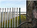
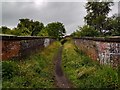
By the side of Audenshaw Reservoirs
From the end bridge over the railway line, spiked metal fences prevent access to the Audenshaw reservoirs over the bank on the left. On the far right across the railway line can be seen the factories on the Arrow Trading Estate on Corporation Road.
Image: © Gerald England
Taken: 28 Oct 2010
0.10 miles
7
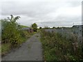
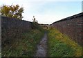
Denton Footpath
Footpath (known locally as Cow Lane) from near Denton Station. The railway line is on the right and the reservoirs are on the right.
Image: © Gerald England
Taken: 15 Oct 2008
0.11 miles
8
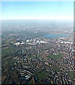
Above Haughton Green and Denton
Audenshaw reservoir appears to the upper right. Taken from an inbound flight to Manchester from Innsbruck.
Image: © Richard Hoare
Taken: 29 Dec 2016
0.12 miles
9
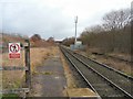
Denton Station
The loneliest station in Greater Manchester.
Image: © Gerald England
Taken: 29 Apr 2008
0.14 miles
10

Denton Station
The view from the side of the Denton railway bridge Image showing the station with industrial units in the background. Despite a catchment area of half a million it has the worst service in the country. Image More information at http://ackworthborn.blogspot.com/2008/05/sky-watch-friday-beyond-once-week.html
Image: © Gerald England
Taken: 15 Oct 2008
0.14 miles