IMAGES TAKEN NEAR TO
M34 3PT
Introduction
This page details the photographs taken nearby to M34 3PT by members of the Geograph project.
The Geograph project started in 2005 with the aim of publishing, organising and preserving representative images for every square kilometre of Great Britain, Ireland and the Isle of Man.

There are currently over 7.5m images from over14,400 individuals and you can help contribute to the project by visiting https://www.geograph.org.uk
Image Map
Images are licensed for reuse under creativecommons.org/licenses/by-sa/2.0
Notes
- Clicking on the map will re-center to the selected point.
- The higher the marker number, the further away the image location is from the centre of the postcode.
Image Listing (11 Images Found)
Images are licensed for reuse under creativecommons.org/licenses/by-sa/2.0
Image
Details
Distance
1
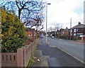
Footpath to St Annes Road
The sign says "Footpath No Horses" but going by the droppings I found further on not everyone heeds the sign.
Image: © Gerald England
Taken: 17 Sep 2009
0.15 miles
2
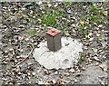
Unknown Object STA 043
This is one of several objects alongside the footpath from Dunkirk Farm to St Annes Road, Denton. It has been suggested that they are piezometer tubes for measuring water pressure (and hence groundwater level) or possibly fixed stations for surveying.
Image: © Gerald England
Taken: 17 Sep 2009
0.15 miles
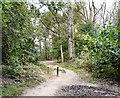
3
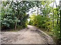
Bridleway to Audenshaw
In Mollets Wood, Denton.
Image: © Gerald England
Taken: 17 Sep 2009
0.15 miles
4
Footpath to Denton
From Dunkirk Farm.
Image: © Gerald England
Taken: 17 Sep 2009
0.21 miles
6
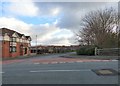
Edward Street
Looking towards St Anne's Road.
Image: © Gerald England
Taken: 22 Feb 2016
0.21 miles
7
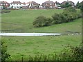
Pond near Denton
In fields at the back of Naysmyth Avenue, Denton, viewed from the side of the River Tame.
Image: © Gerald England
Taken: 9 Sep 2007
0.23 miles
8
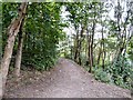
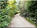
Mollets Wood
Footpath through Mollets Wood by the River Tame.
Image: © Gerald England
Taken: 17 Sep 2009
0.23 miles