IMAGES TAKEN NEAR TO
St. Annes Road, MANCHESTER, M34 3BT
Introduction
This page details the photographs taken nearby to St. Annes Road, M34 3BT by members of the Geograph project.
The Geograph project started in 2005 with the aim of publishing, organising and preserving representative images for every square kilometre of Great Britain, Ireland and the Isle of Man.

There are currently over 7.5m images from over14,400 individuals and you can help contribute to the project by visiting https://www.geograph.org.uk
Image Map
Images are licensed for reuse under creativecommons.org/licenses/by-sa/2.0
Notes
- Clicking on the map will re-center to the selected point.
- The higher the marker number, the further away the image location is from the centre of the postcode.
Image Listing (22 Images Found)
Images are licensed for reuse under creativecommons.org/licenses/by-sa/2.0
Image
Details
Distance
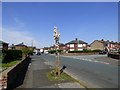
1

Tame Street Recreation Ground
From York Road.
Image: © Gerald England
Taken: 9 May 2016
0.14 miles
2
Blossom on Tame Street
A small tree on Tame Street is displaying blossom.
Image: © Gerald England
Taken: 9 May 2016
0.14 miles

4
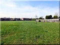
Tame Street Recreation Ground
Looking towards York Road.
Image: © Gerald England
Taken: 9 May 2016
0.16 miles
5
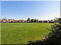
Tame Street Recreation Ground
From York Road.
Image: © Gerald England
Taken: 9 May 2016
0.16 miles
6

Tame Street Recreation Ground
From York Road.
Image: © Gerald England
Taken: 9 May 2016
0.19 miles
7

Last Resting Place
The entrance to Audenshaw Cemetery.
Image: © Roger May
Taken: 17 Aug 2005
0.20 miles
8
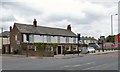
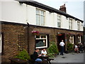
White House Inn
A Sam Smith's pub on Ashton Road.
Image
Image: © Gerald England
Taken: 22 Jun 2017
0.21 miles
9

The White House Inn
One of the bars in this Sam Smith's public house
Image: © Ian S
Taken: 4 Jul 2011
0.21 miles
10
The White House Inn
A Sam Smith's public house
Image: © Ian S
Taken: 4 Jul 2011
0.21 miles