IMAGES TAKEN NEAR TO
Manton Avenue, MANCHESTER, M34 2LH
Introduction
This page details the photographs taken nearby to Manton Avenue, M34 2LH by members of the Geograph project.
The Geograph project started in 2005 with the aim of publishing, organising and preserving representative images for every square kilometre of Great Britain, Ireland and the Isle of Man.

There are currently over 7.5m images from over14,400 individuals and you can help contribute to the project by visiting https://www.geograph.org.uk
Image Map
Images are licensed for reuse under creativecommons.org/licenses/by-sa/2.0
Notes
- Clicking on the map will re-center to the selected point.
- The higher the marker number, the further away the image location is from the centre of the postcode.
Image Listing (7 Images Found)
Images are licensed for reuse under creativecommons.org/licenses/by-sa/2.0
Image
Details
Distance
1
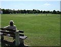
Cricket match
Denton West cricket pitch.
The famous MCC fast bowler, Brian Statham, started his career here in the early 50s.
Image: © Bob Abell
Taken: 30 May 2009
0.17 miles
2
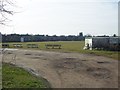
Denton West Cricket Club
Looking across Denton West CC's Windsor Park ground. The club run two teams in the Lancashire County League.
Image: © BatAndBall
Taken: 28 Feb 2013
0.18 miles
3
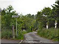
Private Road
This lane does not provide access to Granada Park.
Image: © David Dixon
Taken: 16 May 2011
0.20 miles
4
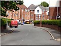
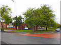
Cromwell Avenue
Off Thornley Lane South.
Image: © Gerald England
Taken: 17 May 2018
0.20 miles
5
West End Library
West End Library, Windsor Road, Denton.
Image: © David Dixon
Taken: 16 May 2011
0.21 miles

7
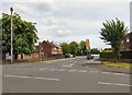
Thornley Lane South
Leading to Dane Bank Primary School (formerly Cromwell Special School).
Image: © Gerald England
Taken: 17 May 2018
0.25 miles