IMAGES TAKEN NEAR TO
Windmill Lane, MANCHESTER, M34 2JF
Introduction
This page details the photographs taken nearby to Windmill Lane, M34 2JF by members of the Geograph project.
The Geograph project started in 2005 with the aim of publishing, organising and preserving representative images for every square kilometre of Great Britain, Ireland and the Isle of Man.

There are currently over 7.5m images from over14,400 individuals and you can help contribute to the project by visiting https://www.geograph.org.uk
Image Map
Images are licensed for reuse under creativecommons.org/licenses/by-sa/2.0
Notes
- Clicking on the map will re-center to the selected point.
- The higher the marker number, the further away the image location is from the centre of the postcode.
Image Listing (9 Images Found)
Images are licensed for reuse under creativecommons.org/licenses/by-sa/2.0
Image
Details
Distance
1
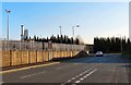
Oldham Street
Leading from the Denton Business Park to Windmill Lane.
Image: © Gerald England
Taken: 9 Nov 2009
0.04 miles
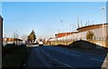
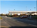
2

Windmill Lane
The road from Dane Bank to Denton. The left turn is Oldham Street leading past business parks towards the motorway network.
Image: © Gerald England
Taken: 9 Nov 2009
0.07 miles
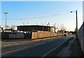
3
Oldham Street
Leading from Windmill Lane towards the M60/M67/A57 Denton Interchange. There are four or five Industrial Parks situated off Oldham Street and a large Sainsbury's supermarket.
Image: © Gerald England
Taken: 9 Nov 2009
0.07 miles
4
Denton Business Park
Gasometers at Denton Business Park on Oldham Street.
Image: © Gerald England
Taken: 9 Nov 2009
0.09 miles
5
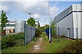
Footpath between the industrial units
This leads off Denton Hall Farm Lane and will eventually reach Jackson Gardens off Town Lane.
Image: © Bill Boaden
Taken: 20 May 2010
0.17 miles
6
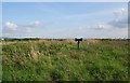
Site of former tipping
Methane has been known to be a problem around this locality.
Image: © Bill Boaden
Taken: 20 May 2010
0.17 miles
7
Qualtex Distribution Centre
An electrical distribution centre on Denton Hall Farm Road off Windmill Lane.
Image: © Gerald England
Taken: 9 Nov 2009
0.18 miles
8
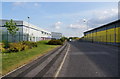
Denton Hall Farm Lane
Though this looks like greenfield development, much of the land was in a poor state beforehand, from activities like tipping.
Image: © Bill Boaden
Taken: 20 May 2010
0.20 miles
9
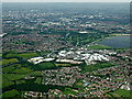
Denton from the air
Part of the Audenshaw reservoirs complex can be seen in the top right quadrant of the photo.
Image: © Thomas Nugent
Taken: 13 Jun 2014
0.22 miles