IMAGES TAKEN NEAR TO
Anson Road, MANCHESTER, M34 2HQ
Introduction
This page details the photographs taken nearby to Anson Road, M34 2HQ by members of the Geograph project.
The Geograph project started in 2005 with the aim of publishing, organising and preserving representative images for every square kilometre of Great Britain, Ireland and the Isle of Man.

There are currently over 7.5m images from over14,400 individuals and you can help contribute to the project by visiting https://www.geograph.org.uk
Image Map
Images are licensed for reuse under creativecommons.org/licenses/by-sa/2.0
Notes
- Clicking on the map will re-center to the selected point.
- The higher the marker number, the further away the image location is from the centre of the postcode.
Image Listing (23 Images Found)
Images are licensed for reuse under creativecommons.org/licenses/by-sa/2.0
Image
Details
Distance
1
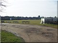
Denton West Cricket Club
Looking across Denton West CC's Windsor Park ground. The club run two teams in the Lancashire County League.
Image: © BatAndBall
Taken: 28 Feb 2013
0.07 miles
2
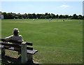
Cricket match
Denton West cricket pitch.
The famous MCC fast bowler, Brian Statham, started his career here in the early 50s.
Image: © Bob Abell
Taken: 30 May 2009
0.09 miles
3
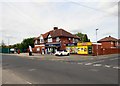
McColl's @ Reddish
The store on the corner of Thornley Lane South and Anson Road was a Londis store before 2012.
Image: © Gerald England
Taken: 17 May 2018
0.11 miles
4

E II R Postbox (SK5 165)
Outside the convenience store Image on Thornley Lane South.
Image: © Gerald England
Taken: 17 May 2018
0.11 miles
5
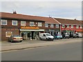
Shops on Thornley Lane South
In the centre is Sprialz hairdressers. Pansies Potters on the left was previously Branching Out florist. Pavilion Indian takeaway on the right was previously Red Rose Tandoori.
Image: © Gerald England
Taken: 17 May 2018
0.11 miles
6
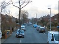
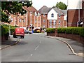
Anson Road
In the Dane Bank area of Denton.
Image: © Gerald England
Taken: 13 Feb 2016
0.16 miles
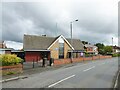
7
Reorganised Church (Latter Day Saints), Denton
Church on Windmill Lane
Image: © David Dixon
Taken: 16 May 2011
0.18 miles
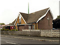
8
Community of Christ Church
On Windmill Lane near Dane Bank
Image: © Kevin Waterhouse
Taken: 30 May 2024
0.18 miles
9
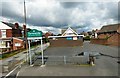
Borough boundary
Thornley Lane South/Windmill Lane is the boundary between Denton/Tameside and Reddish/Stockport. In the background is the rear of the Denton "Community of Christ" Church. Prior to 2001 it was known as the Reorganized Church of Jesus Christ of Latter Day Saints.
Image: © Gerald England
Taken: 25 Jun 2016
0.18 miles
10
Cromwell Avenue
Off Thornley Lane South.
Image: © Gerald England
Taken: 17 May 2018
0.19 miles