IMAGES TAKEN NEAR TO
Windmill Lane, MANCHESTER, M34 2ES
Introduction
This page details the photographs taken nearby to Windmill Lane, M34 2ES by members of the Geograph project.
The Geograph project started in 2005 with the aim of publishing, organising and preserving representative images for every square kilometre of Great Britain, Ireland and the Isle of Man.

There are currently over 7.5m images from over14,400 individuals and you can help contribute to the project by visiting https://www.geograph.org.uk
Image Map
Images are licensed for reuse under creativecommons.org/licenses/by-sa/2.0
Notes
- Clicking on the map will re-center to the selected point.
- The higher the marker number, the further away the image location is from the centre of the postcode.
Image Listing (46 Images Found)
Images are licensed for reuse under creativecommons.org/licenses/by-sa/2.0
Image
Details
Distance


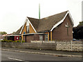
4
Community of Christ, Dane Bank
This is a Mormon church of the Reorganized variety. What that means, I'm not sure. This is right on the border of Stockport and Tameside metropolitan boroughs.
Image: © Bill Boaden
Taken: 20 May 2010
0.13 miles
5
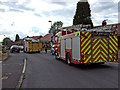
Incident in Windermere Avenue
Nothing serious
Image: © Bob Abell
Taken: 27 Aug 2010
0.13 miles
6
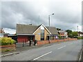
Reorganised Church (Latter Day Saints), Denton
Church on Windmill Lane
Image: © David Dixon
Taken: 16 May 2011
0.14 miles
7
Community of Christ Church
On Windmill Lane near Dane Bank
Image: © Kevin Waterhouse
Taken: 30 May 2024
0.14 miles
8

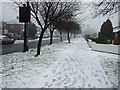
Winter wonderland?
Exceptionally snowy weather
Image: © Bob Abell
Taken: 5 Jan 2010
0.14 miles
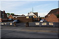
9
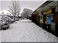
Dane Bank shops
We had 15cms of snow today!
Image: © Bob Abell
Taken: 5 Jan 2010
0.14 miles
10

The Green, Coniston Close
Winter dog walk
Image: © Bob Abell
Taken: 1 Dec 2008
0.14 miles