IMAGES TAKEN NEAR TO
School Road, SALE, M33 7XL

Introduction

This page details the photographs taken nearby to School Road, M33 7XL by members of the Geograph project.

The Geograph project started in 2005 with the aim of publishing, organising and preserving representative images for every square kilometre of Great Britain, Ireland and the Isle of Man.

There are currently over 7.5m images from over14,400 individuals and you can help contribute to the project by visiting https://www.geograph.org.uk

Image Map


Images are licensed for reuse under creativecommons.org/licenses/by-sa/2.0
Notes
  • Clicking on the map will re-center to the selected point.
  • The higher the marker number, the further away the image location is from the centre of the postcode.

Image Listing (190 Images Found)

Images are licensed for reuse under creativecommons.org/licenses/by-sa/2.0
  • ...
Image
Details
Distance
1
School Road, Sale
The main pedestrianised street in Sale town centre.
Image: © Richard Vince Taken: 12 Oct 2013
0.04 miles
2
Sale Town Hall - side aspect
The side wing of the building on Tatton Road was as carefully proportioned as the front aspect, though in the 1970s the overall look was disrupted by modernisation of the public entrance to the registrar's offices in the left centre of the picture. This was performed courtesy of newly formed Trafford Metropolitan Borough Council, which name is spelled out in full on the stonework.
Image: © Whatlep Taken: 30 Jul 2008
0.06 miles
3
Tim Horton's Coffee Shop, Sale
One of a number of cafes and restaurants along the pedestrianised School Road. A change of use for a nice old building which looks like it might have been a bank.
Image: © Des Blenkinsopp Taken: 29 Jun 2018
0.06 miles
4
Sale Town Hall - front aspect
An imposing structure. The war memorial is prominent to the right of the entrance.
Image: © Whatlep Taken: 30 Jul 2008
0.06 miles
5
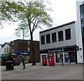
Superdrug and Greggs
Two shops on pedestrianised School Road, Sale. In front of Superdrug is a double-postbox (M33 827) and a box for franked mail.
Image: © Gerald England Taken: 30 Apr 2021
0.07 miles
6
Sale, canal
Bridgewater Canal, seen from Northenden Road.
Image: © Mike Faherty Taken: 28 Jan 2018
0.08 miles
7
Sale Town Hall
With the town's War Memorial Image in front. Sale Urban District Council was formed in 1894 and Ashton-on-Mersey UDC the following year. Sale and Ashton UDCs merged as Sale UDC in 1930 which, in turn, became Sale Borough Council five years later. Sale Town Hall, built in 1914, was extended in 1939/40 but in December, 1940, it was badly damaged by a German incendiary bomb. It was not fully rebuilt until 1952. It has since been included in the extended and award winning Sale Waterside complex which provides a waterside plaza area and enhanced community facilities including the Waterside Arts Centre and Robert Bolt Theatre.
Image: © Gerald England Taken: 20 Sep 2011
0.08 miles
8
Sale Town Hall
Sale Town Hall, located on School Road, is an Edwardian-era municipal building in the town of Sale, in the Metropolitan Borough of Trafford, Greater Manchester, England. It was originally built in 1914, later extended in 1939/40 but in December, 1940, was badly damaged by an incendiary bomb from Nazi German forces. It was not fully rebuilt until 1952.
Image: © Steven Haslington Taken: 10 Nov 2011
0.08 miles
9
Sale Town Hall, School Road, Sale
Image: © Ian S Taken: 1 Mar 2022
0.08 miles
10
Sale town hall
Image: © alan halfpenny Taken: 1 Jan 2006
0.08 miles
  • ...