IMAGES TAKEN NEAR TO
Danefield Road, SALE, M33 7WR
Introduction
This page details the photographs taken nearby to Danefield Road, M33 7WR by members of the Geograph project.
The Geograph project started in 2005 with the aim of publishing, organising and preserving representative images for every square kilometre of Great Britain, Ireland and the Isle of Man.

There are currently over 7.5m images from over14,400 individuals and you can help contribute to the project by visiting https://www.geograph.org.uk
Image Map
Images are licensed for reuse under creativecommons.org/licenses/by-sa/2.0
Notes
- Clicking on the map will re-center to the selected point.
- The higher the marker number, the further away the image location is from the centre of the postcode.
Image Listing (76 Images Found)
Images are licensed for reuse under creativecommons.org/licenses/by-sa/2.0
Image
Details
Distance
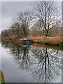
2
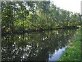
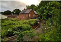
Bridgewater Canal
A leafy section of canal, with birch trees lining the east bank north of White's Bridge.
Image: © Derek Harper
Taken: 19 Aug 2010
0.12 miles
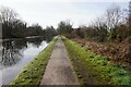
6
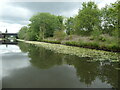
White waterlilies on the Bridgewater canal
At the northern edge of Sale.
Image: © Christine Johnstone
Taken: 22 May 2021
0.14 miles
8
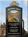
Bridge Inn (sign)
The sign for Image], showing a narrowboat passing under White's Bridge on the Bridgewater Canal.
Image: © David Dixon
Taken: 12 Jan 2012
0.15 miles
9
Barge on the Bridgewater Canal near Stretford
Image: © David Dixon
Taken: 4 Jan 2019
0.15 miles
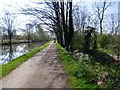
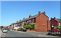
10
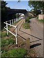
Towpath and road, White's Bridge
The cycleway veers away from the canalside road, which in turn cuvres away to meet Dane Road west of its crossing over White's Bridge.
Image: © Derek Harper
Taken: 19 Aug 2010
0.15 miles