IMAGES TAKEN NEAR TO
Brenton Avenue, SALE, M33 6RA
Introduction
This page details the photographs taken nearby to Brenton Avenue, M33 6RA by members of the Geograph project.
The Geograph project started in 2005 with the aim of publishing, organising and preserving representative images for every square kilometre of Great Britain, Ireland and the Isle of Man.

There are currently over 7.5m images from over14,400 individuals and you can help contribute to the project by visiting https://www.geograph.org.uk
Image Map
Images are licensed for reuse under creativecommons.org/licenses/by-sa/2.0
Notes
- Clicking on the map will re-center to the selected point.
- The higher the marker number, the further away the image location is from the centre of the postcode.
Image Listing (7 Images Found)
Images are licensed for reuse under creativecommons.org/licenses/by-sa/2.0
Image
Details
Distance
1
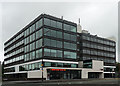
Sale Point, Washway Road, Sale
Probably a 1960s/1970s block which has been given the treatment by Bruntwood, who seem to have pretty much sewn up property development in the Greater Manchester conurbation.
Currently occupied by, among others, a local housing trust.
Image: © Stephen Richards
Taken: 25 Jun 2011
0.10 miles
4
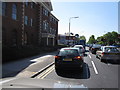
Manchester : Sale - Roadside Shops
Looking along the roadside at Washway Road.
Image: © Lewis Clarke
Taken: 29 Oct 2013
0.21 miles
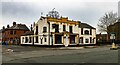
5
Washway Road/Marsland Road junction, Sale
Along the busy A56 heading for Altrincham. Stafford Court office building with offices to let.
Image: © Peter Turner
Taken: 27 Apr 2011
0.22 miles
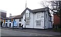
6
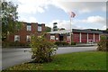
Sale fire station
Sale fire station, Cranleigh Drive, Sale, Greater Manchester
Image: © Kevin Hale
Taken: 30 Oct 2007
0.22 miles
7
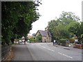
Ashton Lane
This picture taken looking east from SJ781922 along the B5165 Ashton Lane. We think the building in the centre is an old gate house.
Image: © Dave Smethurst
Taken: 5 Sep 2005
0.25 miles