IMAGES TAKEN NEAR TO
Westcourt Road, SALE, M33 6PG
Introduction
This page details the photographs taken nearby to Westcourt Road, M33 6PG by members of the Geograph project.
The Geograph project started in 2005 with the aim of publishing, organising and preserving representative images for every square kilometre of Great Britain, Ireland and the Isle of Man.

There are currently over 7.5m images from over14,400 individuals and you can help contribute to the project by visiting https://www.geograph.org.uk
Image Map
Images are licensed for reuse under creativecommons.org/licenses/by-sa/2.0
Notes
- Clicking on the map will re-center to the selected point.
- The higher the marker number, the further away the image location is from the centre of the postcode.
Image Listing (3 Images Found)
Images are licensed for reuse under creativecommons.org/licenses/by-sa/2.0
Image
Details
Distance
1
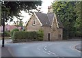
The Gatehouse, Ashton Lane, Sale
Currently for sale, as the board indicates, and according to the details it dates from 1835. I assume this was the gatehouse to the now vanished Ashton Lodge. Lovely bargeboards.
Image: © Derek Harper
Taken: 18 Aug 2010
0.19 miles
2
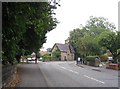
Ashton Lane
This picture taken looking east from SJ781922 along the B5165 Ashton Lane. We think the building in the centre is an old gate house.
Image: © Dave Smethurst
Taken: 5 Sep 2005
0.21 miles