IMAGES TAKEN NEAR TO
Glebelands Road, SALE, M33 6JR
Introduction
This page details the photographs taken nearby to Glebelands Road, M33 6JR by members of the Geograph project.
The Geograph project started in 2005 with the aim of publishing, organising and preserving representative images for every square kilometre of Great Britain, Ireland and the Isle of Man.

There are currently over 7.5m images from over14,400 individuals and you can help contribute to the project by visiting https://www.geograph.org.uk
Image Map
Images are licensed for reuse under creativecommons.org/licenses/by-sa/2.0
Notes
- Clicking on the map will re-center to the selected point.
- The higher the marker number, the further away the image location is from the centre of the postcode.
Image Listing (2 Images Found)
Images are licensed for reuse under creativecommons.org/licenses/by-sa/2.0
Image
Details
Distance
1
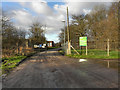
Stretford Wastewater Treatment Plant
The entrance to the Stretford wastewater treatment plant (sewage works) near Kickety Brook at the end of Bradley Lane.
Image: © David Dixon
Taken: 12 Jan 2012
0.22 miles
2
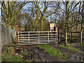
Path to Kickety Brook
The gate at the start of the path from Bradley Lane to Kickety Brook.
Image: © David Dixon
Taken: 12 Jan 2012
0.23 miles