IMAGES TAKEN NEAR TO
Church Terrace, Stamford Street, SALE, M33 6JG
Introduction
This page details the photographs taken nearby to Church Terrace, Stamford Street, M33 6JG by members of the Geograph project.
The Geograph project started in 2005 with the aim of publishing, organising and preserving representative images for every square kilometre of Great Britain, Ireland and the Isle of Man.

There are currently over 7.5m images from over14,400 individuals and you can help contribute to the project by visiting https://www.geograph.org.uk
Image Map
Images are licensed for reuse under creativecommons.org/licenses/by-sa/2.0
Notes
- Clicking on the map will re-center to the selected point.
- The higher the marker number, the further away the image location is from the centre of the postcode.
Image Listing (4 Images Found)
Images are licensed for reuse under creativecommons.org/licenses/by-sa/2.0
Image
Details
Distance
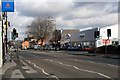
1
Mersey Road
A quiet suburban street which has a road name joining onto the busy A56 main road at a point where it's called Cross Street.
Image: © Mick Garratt
Taken: 6 Feb 2008
0.17 miles
2
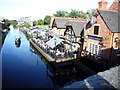
King's Ransom on the Bridgewater Canal, Sale
Taken from Bridge on School Road - Northenden Road.
Image: © Frank Airey
Taken: 25 Sep 2005
0.18 miles