IMAGES TAKEN NEAR TO
Bramble Walk, SALE, M33 5LL
Introduction
This page details the photographs taken nearby to Bramble Walk, M33 5LL by members of the Geograph project.
The Geograph project started in 2005 with the aim of publishing, organising and preserving representative images for every square kilometre of Great Britain, Ireland and the Isle of Man.

There are currently over 7.5m images from over14,400 individuals and you can help contribute to the project by visiting https://www.geograph.org.uk
Image Map
Images are licensed for reuse under creativecommons.org/licenses/by-sa/2.0
Notes
- Clicking on the map will re-center to the selected point.
- The higher the marker number, the further away the image location is from the centre of the postcode.
Image Listing (8 Images Found)
Images are licensed for reuse under creativecommons.org/licenses/by-sa/2.0
Image
Details
Distance
1
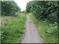
Trans Pennine Trail
Walkers, Cyclists and Horse Riders only.
Image: © David Newton
Taken: 23 Jun 2009
0.05 miles
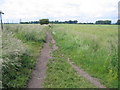
2

Meadowland
From public footpath looking north across meadowland.
Image: © David Newton
Taken: 23 Jun 2009
0.12 miles
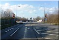
4
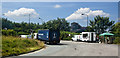
The Mersey Farm, Carrington Lane, Ashton upon Mersey
Image: © Alexander P Kapp
Taken: 26 Feb 2008
0.20 miles
5
Meeting of the Ways
Public footpath across farmland.
Image: © David Newton
Taken: 23 Jun 2009
0.20 miles
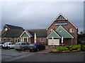
7
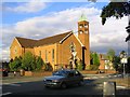
All Saints Church
This is a picture of All Saints Church adjacent to the junction of Carrington lane and Manor Avenue. The picture was taken from SJ766926 looking NE.
Image: © Dave Smethurst
Taken: 28 Aug 2005
0.23 miles
8
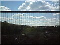
Fields off the A6144
The hedgerow was fenced off from roadworks.
Image: © Gerald England
Taken: 16 Apr 2021
0.23 miles