IMAGES TAKEN NEAR TO
Ripon Grove, SALE, M33 5GZ
Introduction
This page details the photographs taken nearby to Ripon Grove, M33 5GZ by members of the Geograph project.
The Geograph project started in 2005 with the aim of publishing, organising and preserving representative images for every square kilometre of Great Britain, Ireland and the Isle of Man.

There are currently over 7.5m images from over14,400 individuals and you can help contribute to the project by visiting https://www.geograph.org.uk
Image Map
Images are licensed for reuse under creativecommons.org/licenses/by-sa/2.0
Notes
- Clicking on the map will re-center to the selected point.
- The higher the marker number, the further away the image location is from the centre of the postcode.
Image Listing (3 Images Found)
Images are licensed for reuse under creativecommons.org/licenses/by-sa/2.0
Image
Details
Distance
1
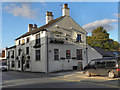
The Old Plough
The Old Plough, Green Lane, Ashton on Mersey
Image: © David Dixon
Taken: 16 Oct 2011
0.22 miles
2
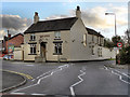
The Buck
Public house at the junction of Buck Lane and Green Lane, Ashton On Mersey.
Image: © David Dixon
Taken: 16 Oct 2011
0.23 miles
3
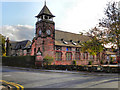
St Martin's School, Ashton upon Mersey
The former school building, at the junction of Green Lane and Carrington Lane, was once the village school. The clock tower was erected in 1874 but the school itself originally dates from 1818.
Image: © David Dixon
Taken: 16 Oct 2011
0.25 miles