IMAGES TAKEN NEAR TO
Harboro Road, SALE, M33 5AF
Introduction
This page details the photographs taken nearby to Harboro Road, M33 5AF by members of the Geograph project.
The Geograph project started in 2005 with the aim of publishing, organising and preserving representative images for every square kilometre of Great Britain, Ireland and the Isle of Man.

There are currently over 7.5m images from over14,400 individuals and you can help contribute to the project by visiting https://www.geograph.org.uk
Image Map
Images are licensed for reuse under creativecommons.org/licenses/by-sa/2.0
Notes
- Clicking on the map will re-center to the selected point.
- The higher the marker number, the further away the image location is from the centre of the postcode.
Image Listing (6 Images Found)
Images are licensed for reuse under creativecommons.org/licenses/by-sa/2.0
Image
Details
Distance
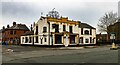
1
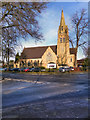
St Mary Magdalene Church, Ashton-on-Mersey
St Mary Magdalene's Church, at the corner of Harboro Road and Moss Lane, was built in 1874.
Image: © David Dixon
Taken: 15 Jan 2012
0.21 miles
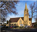
2
The Parish Church of St Mary Magdalene. Ashton-upon-Mersey
St Mary Magdalene's Church, at the corner of Harboro Road and Moss Lane, was built in 1874.
Image: © David Dixon
Taken: 15 Jan 2012
0.21 miles
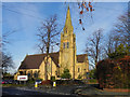
3
Church of St Mary Magdalene
On Harboro Road
Image: © Kevin Waterhouse
Taken: 8 Oct 2023
0.21 miles
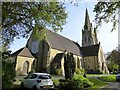
4
St Mary's Church, Ashton-on-Mersey
The Parish Church of St Mary Magdalene, Ashton-upon-Mersey, was built in 1874.
Image: © David Dixon
Taken: 15 Jan 2012
0.22 miles
5
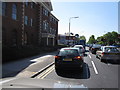
Washway Road/Marsland Road junction, Sale
Along the busy A56 heading for Altrincham. Stafford Court office building with offices to let.
Image: © Peter Turner
Taken: 27 Apr 2011
0.22 miles