IMAGES TAKEN NEAR TO
Fonthill Grove, SALE, M33 4FR
Introduction
This page details the photographs taken nearby to Fonthill Grove, M33 4FR by members of the Geograph project.
The Geograph project started in 2005 with the aim of publishing, organising and preserving representative images for every square kilometre of Great Britain, Ireland and the Isle of Man.

There are currently over 7.5m images from over14,400 individuals and you can help contribute to the project by visiting https://www.geograph.org.uk
Image Map
Images are licensed for reuse under creativecommons.org/licenses/by-sa/2.0
Notes
- Clicking on the map will re-center to the selected point.
- The higher the marker number, the further away the image location is from the centre of the postcode.
Image Listing (25 Images Found)
Images are licensed for reuse under creativecommons.org/licenses/by-sa/2.0
Image
Details
Distance
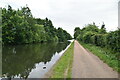
2
Canal towpath users, Timperley
The Bridgewater canal towpath is well maintained and well used.
Image: © Christine Johnstone
Taken: 29 May 2021
0.06 miles
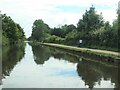
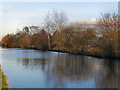
4
Bridgewater Canal
The Bridgewater Canal, between Timperley and Brooklands.
Image: © David Dixon
Taken: 12 Jan 2012
0.07 miles
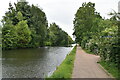
5
Bridgewater Canal
The Bridgewater Canal, between Timperley and Brooklands. A metrolink tram can just be spotted behind the trees; the tramway follows the line of the canal between Timperley and Stretford.
Image: © David Dixon
Taken: 12 Jan 2012
0.07 miles
6

Sinderland Brook, in the direction of Bridgewater Canal
This brook is interesting as it separates Manchester from Cheshire postcodes in Timperley.
Image: © Isaac Letterhead
Taken: 15 Jun 2008
0.07 miles
7

Path by Baguley Brook
The brook has just passed under the Bridgewater Canal
Image: © Kevin Waterhouse
Taken: 27 Feb 2023
0.07 miles
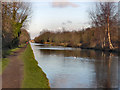
8
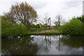
The Bridgewater Canal near Timperley
The Metrolink line runs by the canal on the other side. Beyond that is Riddings Allotments.
Image: © Bill Boaden
Taken: 2 May 2015
0.07 miles
9
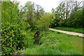
Sinderland Brook
A small brook which flows under the Bridgewater Canal from where it is viewed here. A path runs along each side.
Image: © Bill Boaden
Taken: 2 May 2015
0.07 miles