IMAGES TAKEN NEAR TO
Washway Road, SALE, M33 4BL
Introduction
This page details the photographs taken nearby to Washway Road, M33 4BL by members of the Geograph project.
The Geograph project started in 2005 with the aim of publishing, organising and preserving representative images for every square kilometre of Great Britain, Ireland and the Isle of Man.

There are currently over 7.5m images from over14,400 individuals and you can help contribute to the project by visiting https://www.geograph.org.uk
Image Map
Images are licensed for reuse under creativecommons.org/licenses/by-sa/2.0
Notes
- Clicking on the map will re-center to the selected point.
- The higher the marker number, the further away the image location is from the centre of the postcode.
Image Listing (4 Images Found)
Images are licensed for reuse under creativecommons.org/licenses/by-sa/2.0
Image
Details
Distance
3
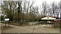
Walton Park
With the open-air shed for displaying miniature railway engines. There is also a circuit within the park to run trains.
Image: © Kevin Waterhouse
Taken: 27 Feb 2023
0.25 miles
4
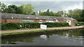
Walton Park Sports Centre
Home to Trafford Rowing Club and other organisations. The rowers were out on the Bridgewater canal.
Image: © Christine Johnstone
Taken: 22 May 2021
0.25 miles