IMAGES TAKEN NEAR TO
Washway Road, SALE, M33 4AL
Introduction
This page details the photographs taken nearby to Washway Road, M33 4AL by members of the Geograph project.
The Geograph project started in 2005 with the aim of publishing, organising and preserving representative images for every square kilometre of Great Britain, Ireland and the Isle of Man.

There are currently over 7.5m images from over14,400 individuals and you can help contribute to the project by visiting https://www.geograph.org.uk
Image Map
Images are licensed for reuse under creativecommons.org/licenses/by-sa/2.0
Notes
- Clicking on the map will re-center to the selected point.
- The higher the marker number, the further away the image location is from the centre of the postcode.
Image Listing (9 Images Found)
Images are licensed for reuse under creativecommons.org/licenses/by-sa/2.0
Image
Details
Distance
2
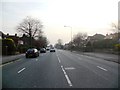
Washway Road/Marsland Road junction, Sale
Along the busy A56 heading for Altrincham. Stafford Court office building with offices to let.
Image: © Peter Turner
Taken: 27 Apr 2011
0.11 miles
4
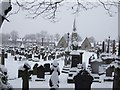
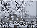
Brooklands cemetery in the snow
Image: © Bernie O'Brien White
Taken: 5 Jan 2010
0.20 miles
5
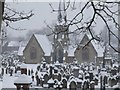
Brooklands cemetery in the snow
Image: © Bernie O'Brien White
Taken: 5 Jan 2010
0.22 miles
6
Brooklands cemetery in the snow
Image: © Bernie O'Brien White
Taken: 5 Jan 2010
0.22 miles
7
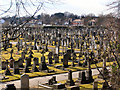
Sale Brooklands Cemetery
The southern side.
Image: © David Dixon
Taken: 11 Mar 2010
0.22 miles
8
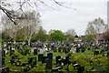
Sale Cemetery
As seen from the canal towpath.
Image: © Bill Boaden
Taken: 2 May 2015
0.23 miles
9
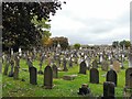
Brooklands Cemetery
From the footpath North of Marsland Road.
Image: © Gerald England
Taken: 20 Sep 2011
0.25 miles