IMAGES TAKEN NEAR TO
Princes Drive, SALE, M33 3JB
Introduction
This page details the photographs taken nearby to Princes Drive, M33 3JB by members of the Geograph project.
The Geograph project started in 2005 with the aim of publishing, organising and preserving representative images for every square kilometre of Great Britain, Ireland and the Isle of Man.

There are currently over 7.5m images from over14,400 individuals and you can help contribute to the project by visiting https://www.geograph.org.uk
Image Map
Images are licensed for reuse under creativecommons.org/licenses/by-sa/2.0
Notes
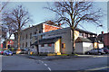
- Clicking on the map will re-center to the selected point.
- The higher the marker number, the further away the image location is from the centre of the postcode.
Image Listing (32 Images Found)
Images are licensed for reuse under creativecommons.org/licenses/by-sa/2.0
Image
Details
Distance
1
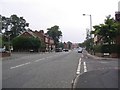
A6144
This picture was taken from SJ797913 looking Northeast along Marsland Road (A6144) towards Sale Moor.
Image: © Dave Smethurst
Taken: 5 Sep 2005
0.01 miles
4
Trinity Methodist Church
Trinity Methodist Church first opened for worship on Northenden Road in 1875 when the congregation from the Broad Lane Chapel, built in 1820, moved into its new premises. In 1980, the main Church building Image was sold and worship continued in the converted Church hall. https://www.salemethodistchurches.org.uk/churches/trinity-methodist-church
Image: © Gerald England
Taken: 23 Feb 2019
0.17 miles
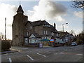
5
Trinity Methodist Church
The Methodist church on Trinity Road. The large building behind is Image], the former Trinity Chapel which has now been converted into offices.
Image: © David Dixon
Taken: 12 Jan 2012
0.17 miles
6
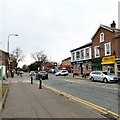
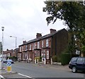
Northenden Road, Sale Moor
The B5166 at Sale Moor. On one side of Temple Road is a Texaco garage and on the other side is The Temple Inn which according to its sign Image is a Craft Union Free House. At one time it had been a John Smiths house.
Image: © Gerald England
Taken: 11 Mar 2017
0.18 miles
7

Sign of the Temple Inn
The sign for the Temple Inn on Northenden Road Image according to which it is a Craft Union Free House.
Image: © Gerald England
Taken: 11 Mar 2017
0.18 miles
8

Former Trinity Chapel
The former chapel on Northenden Road. Originally built in 1875, it is now converted into offices.
See also Image
Image: © David Dixon
Taken: 12 Jan 2012
0.18 miles
9
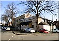
The Moorfield
Large pub/restaurant at the corner of Cromer Road and Marsland Road.
Image: © David Dixon
Taken: 12 Jan 2012
0.18 miles
10
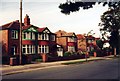
Sale - Derbyshire Road South houses
Inter-war semi-detached houses are typical of this road and several parts of Sale.
Image: © Peter Whatley
Taken: 10 Oct 1991
0.18 miles