IMAGES TAKEN NEAR TO
Rifle Road, SALE, M33 2LX
Introduction
This page details the photographs taken nearby to Rifle Road, M33 2LX by members of the Geograph project.
The Geograph project started in 2005 with the aim of publishing, organising and preserving representative images for every square kilometre of Great Britain, Ireland and the Isle of Man.

There are currently over 7.5m images from over14,400 individuals and you can help contribute to the project by visiting https://www.geograph.org.uk
Image Map
Images are licensed for reuse under creativecommons.org/licenses/by-sa/2.0
Notes
- Clicking on the map will re-center to the selected point.
- The higher the marker number, the further away the image location is from the centre of the postcode.
Image Listing (49 Images Found)
Images are licensed for reuse under creativecommons.org/licenses/by-sa/2.0
Image
Details
Distance
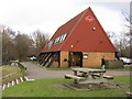
2
Visitor Centre, Sale Water Park
http://www.merseyvalley.org.uk/site/index.php?option=content&task=view&id=51&Itemid=73 - Mersey Valley Countryside Warden Service.
Image: © David Dixon
Taken: 10 Apr 2011
0.01 miles
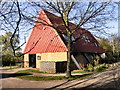
4
Mersey Valley Country Park Visitor Centre
The Mersey Valley Country Park forms a green lung between Manchester and Trafford. Unfortunately the cafe at the Visitor Centre was not open on the Tuesday we visited.
Image: © John Rostron
Taken: 4 Sep 2012
0.07 miles
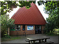
5
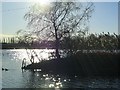
Sale Water Park
This is a view across the Water Park looking SW towards the M60
Image: © Dave Smethurst
Taken: 23 Jan 2005
0.07 miles
6
Designer Wetland
Man-made wetland environment in Sale Water Park.
Image: © Peter Whatley
Taken: 23 Jan 2009
0.07 miles
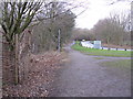
7
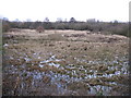
Flood Alleviation Channel, Sale Ees Flood Basin
To alleviate flooding in the Mersey Valley, the Environment Agency operates several flood basins. When water levels are too high, water from the river Mersey flows along this channel from a sluice west of the Jackson's Boat pub to flood open land at Sale Water Park. The channel also provides valuable wildlife habitats. When not in use it gives no hint of its main function.
Image: © Phil Champion
Taken: 25 May 2007
0.08 miles
9
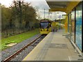
Tram Leaving Sale Water park
Metrolink tram number 3062 departs from the outbound platform at Sale Water Park on the route towards Manchester Airport.
Situated alongside Rifle Road, near to Junction 6 of the M60, the Sale Water Park tram stop serves Sale Water Park and nearby housing. It has an island platform with ramps down to track-level pedestrian crossings of the inbound line.
Image: © David Dixon
Taken: 4 Nov 2014
0.08 miles
10
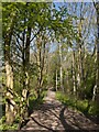
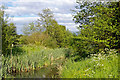
A path in Chorlton Ees and Ivy Green Nature Reserve
The word Ees (plural of ee) is an archaic English term for a piece of land liable to flood, or water a meadow. It is derived from the Anglo-Saxon. It is also used for a piece of firm land in a fen and for land situated on a stream or between streams.
Image: © Ian Greig
Taken: 23 Apr 2015
0.09 miles