IMAGES TAKEN NEAR TO
Fairy Lane, SALE, M33 2JU
Introduction
This page details the photographs taken nearby to Fairy Lane, M33 2JU by members of the Geograph project.
The Geograph project started in 2005 with the aim of publishing, organising and preserving representative images for every square kilometre of Great Britain, Ireland and the Isle of Man.

There are currently over 7.5m images from over14,400 individuals and you can help contribute to the project by visiting https://www.geograph.org.uk
Image Map
Images are licensed for reuse under creativecommons.org/licenses/by-sa/2.0
Notes
- Clicking on the map will re-center to the selected point.
- The higher the marker number, the further away the image location is from the centre of the postcode.
Image Listing (6 Images Found)
Images are licensed for reuse under creativecommons.org/licenses/by-sa/2.0
Image
Details
Distance
1

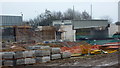
Football Ground and Sub station
This section of the football playing fields and substation in the background is found in the eastern half of the square.
Image: © Pam Brophy
Taken: 29 Jul 2005
0.08 miles
2
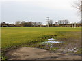
Football Pitches near the M60, Northern Moor
Image: © Peter Whatley
Taken: 20 Jan 2009
0.14 miles
3
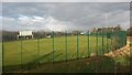
Sports field between tram line and motorway
With a very big fence!
Image: © David Martin
Taken: 16 Feb 2017
0.15 miles
4
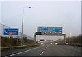
M60 Metrolink Bridge
The approaches to the Metrolink bridge over the M60 under construction. A subway carrying the Metrolink will maintain access between the playing fields.
Image: © Richard Cooke
Taken: 9 Feb 2013
0.20 miles