IMAGES TAKEN NEAR TO
Dane Road, SALE, M33 2BZ
Introduction
This page details the photographs taken nearby to Dane Road, M33 2BZ by members of the Geograph project.
The Geograph project started in 2005 with the aim of publishing, organising and preserving representative images for every square kilometre of Great Britain, Ireland and the Isle of Man.

There are currently over 7.5m images from over14,400 individuals and you can help contribute to the project by visiting https://www.geograph.org.uk
Image Map
Images are licensed for reuse under creativecommons.org/licenses/by-sa/2.0
Notes
- Clicking on the map will re-center to the selected point.
- The higher the marker number, the further away the image location is from the centre of the postcode.
Image Listing (15 Images Found)
Images are licensed for reuse under creativecommons.org/licenses/by-sa/2.0
Image
Details
Distance
1
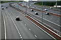
M60 Motorway adjacent to Sale Water Park
Between 2003 and 2006 the M60 was widened between junctions 5 and 8. The section through the Mersey Valley was opened in 1974 as a 4 lane road, then designated the M63. The motorway is now more than twice as wide, with 6 lanes on the main section and a two lane distributor / collector road on either side. Photo taken from the new Sale Water Park footbridge.
Image: © Phil Champion
Taken: 25 May 2007
0.22 miles
2
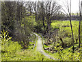
Path to Cow Lane
The path from Image] to Cow Lane on the Sale side of the motorway.
Image: © David Dixon
Taken: 10 Apr 2011
0.23 miles
3

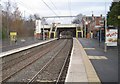
Dane Road Station
Metrolink tram station. A Bury-bound tram has just left.
Image: © Gerald England
Taken: 17 May 2012
0.24 miles
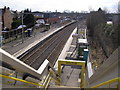
4
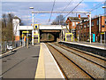
Dane Road Station
Looking towards the Dane Road bridge, in the direction of Manchester.
Image: © David Dixon
Taken: 11 Mar 2010
0.24 miles
5
Dane Road Station
Looking towards Sale and Altrincham
Image: © David Dixon
Taken: 11 Mar 2010
0.24 miles
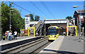
6

Dane Road Station
Metrolink tram station looking towards Altrincham.
Image: © Gerald England
Taken: 17 May 2012
0.24 miles
7
Dane Road railway (now Metrolink) station, Greater Manchester
Opened in 1931 by the Manchester South Junction & Altrincham Railway on the line from Manchester London Road (now Piccadilly) to Altrincham, this station converted to Metrolink operation in 1992.
View north east towards Stretford and Central Manchester
Image: © Nigel Thompson
Taken: 11 Dec 2010
0.24 miles
8
Dane Road Tram Stop
Opened as an ordinary station in 1931 and continued in operation as such until 1991. Reopened as a Metrolink tram stop in 1992. https://en.wikipedia.org/wiki/Dane_Road_tram_stop
Image: © Des Blenkinsopp
Taken: 30 Jun 2018
0.24 miles
10
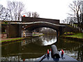
Bridgewater Canal: Dr. White's Bridge No 36
Image: © Dr Neil Clifton
Taken: 29 Mar 2015
0.24 miles