IMAGES TAKEN NEAR TO
Blackfriars Street, MANCHESTER, M3 2EQ
Introduction
This page details the photographs taken nearby to Blackfriars Street, M3 2EQ by members of the Geograph project.
The Geograph project started in 2005 with the aim of publishing, organising and preserving representative images for every square kilometre of Great Britain, Ireland and the Isle of Man.

There are currently over 7.5m images from over14,400 individuals and you can help contribute to the project by visiting https://www.geograph.org.uk
Image Map
Images are licensed for reuse under creativecommons.org/licenses/by-sa/2.0
Notes
- Clicking on the map will re-center to the selected point.
- The higher the marker number, the further away the image location is from the centre of the postcode.
Image Listing (2174 Images Found)
Images are licensed for reuse under creativecommons.org/licenses/by-sa/2.0
Image
Details
Distance
1
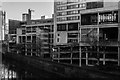
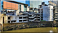
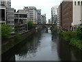
River Irwell
Buildings alongside the River Irwell, seen from Blackfriars Bridge.
Image: © Peter McDermott
Taken: 3 Jan 2020
0.02 miles
2
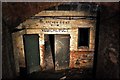
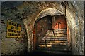
Manchester Cathedral steps
The arches were used as an air raid shelter during W.W II The conversion, which included additional brick blast walls, took three months at a cost of £10,150 and provided shelter for 1619 people.
Click http://blog.myspace.com/index.cfm?fuseaction=blog.view&friendID=265602590&blogID=430373437 for many more full size pictures, with archive shots, and full history of the Manchester Cathedral steps.
Image: © philld
Taken: 4 Sep 2008
0.02 miles
3
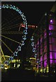
The Manchester wheel reflected in Harvey Nicholl's store
Image: © Steve Fareham
Taken: 12 Jul 2009
0.03 miles
5
Manchester Cathedral steps
The arches were used as an air raid shelter during W.W II The conversion, which included additional brick blast walls, took three months at a cost of £10,150 and provided shelter for 1619 people.
Click http://blog.myspace.com/index.cfm?fuseaction=blog.view&friendID=265602590&blogID=430373437 for many more full size pictures, with archive shots, and full history of the Manchester Cathedral steps.
Image: © philld
Taken: 4 Sep 2008
0.03 miles
6
Manchester Cathedral steps
The arches were used as an air raid shelter during W.W II The conversion, which included additional brick blast walls, took three months at a cost of £10,150 and provided shelter for 1619 people.
Click http://blog.myspace.com/index.cfm?fuseaction=blog.view&friendID=265602590&blogID=430373437 for many more full size pictures, with archive shots, and full history of the Manchester Cathedral steps.
Image: © philld
Taken: 4 Sep 2008
0.03 miles
7
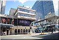
Premier House
Demolition of Premier House.
Image: © Peter McDermott
Taken: 27 Feb 2022
0.03 miles
8
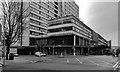
Premier House
Disused office block in Manchester.
Image: © Peter McDermott
Taken: 27 Dec 2019
0.03 miles
9
The River Irwell at Victoria Bridge
Looking westward towards Blackfriars Bridge, the opposite direction to Image
Image: © Eirian Evans
Taken: 23 Apr 2009
0.03 miles
10
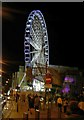
Manchester's big wheel
The purple lights on the right are Harvey Nicholl's store.
Image: © Steve Fareham
Taken: 12 Jul 2009
0.03 miles