IMAGES TAKEN NEAR TO
Deansgate, MANCHESTER, M3 2BY
Introduction
This page details the photographs taken nearby to Deansgate, M3 2BY by members of the Geograph project.
The Geograph project started in 2005 with the aim of publishing, organising and preserving representative images for every square kilometre of Great Britain, Ireland and the Isle of Man.

There are currently over 7.5m images from over14,400 individuals and you can help contribute to the project by visiting https://www.geograph.org.uk
Image Map (2522 Images)


Leaflet Map data © OpenStreetMap
Images are licensed for reuse under creativecommons.org/licenses/by-sa/2.0
Notes
- Clicking on the map will re-center to the selected point.
- The higher the marker number, the further away the image location is from the centre of the postcode.
Image Listing (2522 Images Found)
Images are licensed for reuse under creativecommons.org/licenses/by-sa/2.0
Image
Details
Distance
1
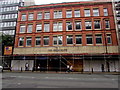
123 Deansgate, Manchester
123 Deansgate is a 4-storey building on the north side of the A56 Deansgate, opposite Wood Street.
Image: © Jaggery
Taken: 10 Sep 2016
0.01 miles
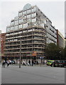
2
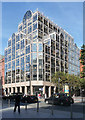
125 Deansgate
The 125 Deansgate development in Manchester.
Image: © Peter McDermott
Taken: 1 Oct 2017
0.01 miles
3
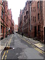
Wood Street, central Manchester
Looking towards the A56 Deansgate. Double yellow lines on both sides of the
narrow street indicate no parking at any time.
Image: © Jaggery
Taken: 10 Sep 2016
0.01 miles
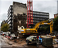
4
Deansgate office block under scaffolding, Manchester
Viewed across the A56 Deansgate on September 10th 2016.
The building is on the corner of Brazennose Street.
Image: © Jaggery
Taken: 10 Sep 2016
0.02 miles
5
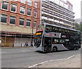
X43 bus in Deansgate, Manchester
The double-decker bus heading south on the A56 Deansgate shows its destination as Burnley via Nelson.
Text on the side of the bus shows The Witch Way, extending from Manchester to Skipton via Prestwich, Rawtenstall, Burnley and Colne.
Image: © Jaggery
Taken: 10 Sep 2016
0.02 miles
6
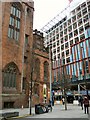
Old and new on Deansgate
On the left is the Grade I listed https://historicengland.org.uk/listing/the-list/list-entry/1217800 John Rylands Library. Across the road on the right is the new "125 Deansgate" which is currently under construction by the Marcus Worthington Group http://125deansgate.com/
Image: © Gerald England
Taken: 2 Jan 2019
0.02 miles
7
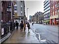
Deansgate
The A56 running through Manchester city centre.
Image: © David Dixon
Taken: 21 Jan 2015
0.02 miles
8
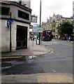
Junction of Wood Street and Deansgate, Manchester
From the left, Wood Street joins the A56 Deansgate. The Lost Dene pub is on the corner.
Image: © Jaggery
Taken: 10 Sep 2016
0.02 miles
9
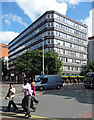
Lincoln House, Deansgate, Manchester
By Holford Associates, 1986, and, with its pink granite piers and reflective glass, Pevsner said, "the earliest example of brash 1980s glitter in the centre." It heralded a descent into a sea of meretricious post-modernism, teeming with counterfeit columns, gimcrack gables and perfunctory pediments.
Image: © Stephen Richards
Taken: 23 Jul 2011
0.02 miles
10
121 Deansgate, Manchester
John Dalton House, an L-shaped 1960s/1970s office block with its long side facing John Dalton Street. Shops at ground floor. Unidentified cladding between the windows.
Image: © Stephen Richards
Taken: 23 Jun 2011
0.02 miles