IMAGES TAKEN NEAR TO
Stretford, MANCHESTER, M32 9UP
Introduction
This page details the photographs taken nearby to M32 9UP by members of the Geograph project.
The Geograph project started in 2005 with the aim of publishing, organising and preserving representative images for every square kilometre of Great Britain, Ireland and the Isle of Man.

There are currently over 7.5m images from over14,400 individuals and you can help contribute to the project by visiting https://www.geograph.org.uk
Image Map
Images are licensed for reuse under creativecommons.org/licenses/by-sa/2.0
Notes
- Clicking on the map will re-center to the selected point.
- The higher the marker number, the further away the image location is from the centre of the postcode.
Image Listing (76 Images Found)
Images are licensed for reuse under creativecommons.org/licenses/by-sa/2.0
Image
Details
Distance
1
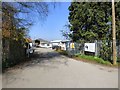
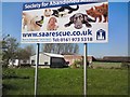
Society for Abandoned Animals
The Society for Abandoned Animals was originally established in 1966 by Peggy Henderson and her colleagues to deal with the large numbers of animals displaced by the housing clearance in the Hulme area of Manchester.
Their current location, Mosley Acre Farm, was purchased in 1994 and named "The Peggy Henderson Animal Sanctuary" after their founder, although the charity name remains as it was originally registered with the Charity commission by Peggy in 1967 "Society for Abandoned Animals". http://www.saarescue.co.uk/about-us/
Image: © Gerald England
Taken: 8 Apr 2017
0.00 miles
2
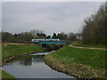
Tram Crossing the Mersey
A bridge carries the Metrolink line over the River Mersey. The bridge runs alongside Barfoot Bridge which carries the Bridgewater Canal over the Mersey.
Image: © Paul Lockett
Taken: 31 Mar 2009
0.02 miles
3
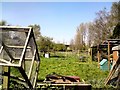
Moseley Acre Farm
Home of the Peggy Henderson Animal Sanctuary Image
Image: © Gerald England
Taken: 8 Apr 2017
0.02 miles
4
Society for Abandoned Animals
The Society for Abandoned Animals was originally established in 1966 by Peggy Henderson and her colleagues to deal with the large numbers of animals displaced by the housing clearance in the Hulme area of Manchester.
Their current location, Mosley Acre Farm, was purchased in 1994 and named "The Peggy Henderson Animal Sanctuary" after their founder, although the charity name remains as it was originally registered with the Charity commission by Peggy in 1967 "Society for Abandoned Animals". http://www.saarescue.co.uk/about-us/
Image: © Gerald England
Taken: 8 Apr 2017
0.02 miles
5
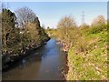
River Mersey
From Barfoot Bridge where the Bridgewater Canal passes over the river on an aqueduct.
Image: © Gerald England
Taken: 8 Apr 2017
0.04 miles
6
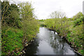
The River Mersey near Sale
Viewed from the Bridgewater Canal under which it flows.
Image: © Bill Boaden
Taken: 2 May 2015
0.05 miles
8
Barfoot Bridge
The Metrolink with the Bridgewater Canal beyond cross the River Mersey
Image: © Ian Greig
Taken: 23 Apr 2015
0.05 miles
9
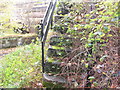
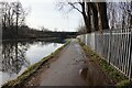
Old stone steps
The old stone steps leading up to the Bridgewater Canal. Climb up them & come out almost opposite the Old Watch House cruising club house.
Image: © Christine Courtney
Taken: 25 Oct 2008
0.05 miles
10
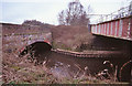
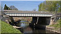
River Mersey at Barfoot Bridge
The bridge on the left is an aqueduct carrying the Bridgewater Canal.
The bridge on the right was built by the Manchester South Junction & Altrincham Railway. Only 2 of the original 4 tracks now exist, and are now used by Metrolink.
Image: © Ian Taylor
Taken: 9 Mar 2009
0.05 miles