IMAGES TAKEN NEAR TO
Farm Avenue, MANCHESTER, M32 9TW
Introduction
This page details the photographs taken nearby to Farm Avenue, M32 9TW by members of the Geograph project.
The Geograph project started in 2005 with the aim of publishing, organising and preserving representative images for every square kilometre of Great Britain, Ireland and the Isle of Man.

There are currently over 7.5m images from over14,400 individuals and you can help contribute to the project by visiting https://www.geograph.org.uk
Image Map
Images are licensed for reuse under creativecommons.org/licenses/by-sa/2.0
Notes
- Clicking on the map will re-center to the selected point.
- The higher the marker number, the further away the image location is from the centre of the postcode.
Image Listing (7 Images Found)
Images are licensed for reuse under creativecommons.org/licenses/by-sa/2.0
Image
Details
Distance
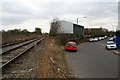
1
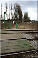
Railway foot crossing
The path leads from St. Modwen Road to Old Hall Road, Stretford, across Lostock Park.
Image: © David Lally
Taken: 17 Mar 2010
0.18 miles
2
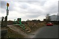
Steps to a railway crossing
On St. Modwen Road, Trafford. The tracks that the path crosses is a branch line supplying the rail-freight terminal on Barton Dock Road a short distance from here in Image
Image: © David Lally
Taken: 17 Mar 2010
0.19 miles
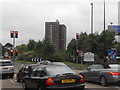
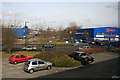
4
St. Modwen Road and branch line
St Modwen Road. is a short T-shaped cul-de-sac of industrial units.
The tracks lead to the rail-freight terminal on Barton Dock Road next to the Trafford Centre shopping complex.
Image: © David Lally
Taken: 17 Mar 2010
0.19 miles
5
St. Modwen Road
Taken from the first floor of one of the units. Looking here over the section of the road which leads to Barton Dock Road.
Image: © David Lally
Taken: 17 Mar 2010
0.23 miles
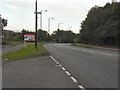
6
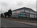
Kellogg's Warehouse - Barton Dock Road
Image: © Anthony Parkes
Taken: 22 Jul 2010
0.25 miles