IMAGES TAKEN NEAR TO
Berkeley Avenue, MANCHESTER, M32 9TJ
Introduction
This page details the photographs taken nearby to Berkeley Avenue, M32 9TJ by members of the Geograph project.
The Geograph project started in 2005 with the aim of publishing, organising and preserving representative images for every square kilometre of Great Britain, Ireland and the Isle of Man.

There are currently over 7.5m images from over14,400 individuals and you can help contribute to the project by visiting https://www.geograph.org.uk
Image Map
Images are licensed for reuse under creativecommons.org/licenses/by-sa/2.0
Notes
- Clicking on the map will re-center to the selected point.
- The higher the marker number, the further away the image location is from the centre of the postcode.
Image Listing (7 Images Found)
Images are licensed for reuse under creativecommons.org/licenses/by-sa/2.0
Image
Details
Distance
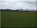
2
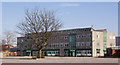
Stretford, Lostock College
Secondary school on Selby Road: http://www.lostock.trafford.sch.uk/about-us/2077.html
Image: © Mike Faherty
Taken: 26 Dec 2012
0.17 miles
3
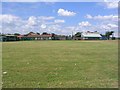
Lostock School
View of Lostock Secondary School from Chatsworth Road at SJ782952.
Image: © Dave Smethurst
Taken: 17 Jul 2005
0.22 miles
5
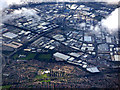
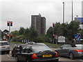
Manchester from the air
The Trafford Park area of the city, seen from above Altrincham (5 miles south) from a Prague bound flight from Manchester.
Image: © Thomas Nugent
Taken: 6 Jul 2020
0.24 miles
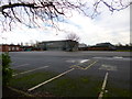
6
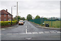
Selby Road
Running down the side of Lostock College which is to the right.
Image: © Bill Boaden
Taken: 9 May 2019
0.24 miles