IMAGES TAKEN NEAR TO
Addison Road, MANCHESTER, M32 9LH
Introduction
This page details the photographs taken nearby to Addison Road, M32 9LH by members of the Geograph project.
The Geograph project started in 2005 with the aim of publishing, organising and preserving representative images for every square kilometre of Great Britain, Ireland and the Isle of Man.

There are currently over 7.5m images from over14,400 individuals and you can help contribute to the project by visiting https://www.geograph.org.uk
Image Map
Images are licensed for reuse under creativecommons.org/licenses/by-sa/2.0
Notes
- Clicking on the map will re-center to the selected point.
- The higher the marker number, the further away the image location is from the centre of the postcode.
Image Listing (34 Images Found)
Images are licensed for reuse under creativecommons.org/licenses/by-sa/2.0
Image
Details
Distance
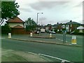
1
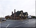
Derbyshire Lane Shops
Row of shops at the corner of Derbyshire Lane West and Addison Road.
Image: © David Dixon
Taken: 25 Sep 2011
0.04 miles
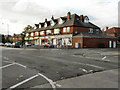
2
The Melville
The Melville public house on Barton Road, Stretford.
Image: © David Dixon
Taken: 25 Sep 2011
0.05 miles
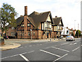
3
Stretford, The Melville
Brewer's Tudor pub on the corner of Barton and Melville Roads; central bar, public bar left, lounge right; conservatory, terrace, wooden panelling and beams; TV and games machines. Cask ale on offer at my visit: Holts Bitter. For some customer comments, see http://www.beerintheevening.com/pubs/s/20/20850/Melville/Stretford
Image: © Mike Faherty
Taken: 26 Dec 2012
0.06 miles
4
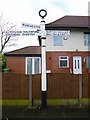
Old Direction Sign - Signpost by Barton Road, Trafford Park
Annulus finial - 3 arms; Needham Stretford halo by the UC road, in parish of Stretford (Trafford District), Trafford Park, Barton Road next to junction with Derbyshire Lane, in pavement, West side of road.
Surveyed
Milestone Society National ID: LA_SJ7894B
Image: © Milestone Society
Taken: Unknown
0.07 miles
5
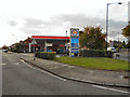
Esso Service Station, Sevenways
The petrol station on the corner of Bradfield Road and Derbyshire Lane West, at the Sevenways junction.
Image: © David Dixon
Taken: 25 Sep 2011
0.08 miles
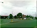
6
Seven Ways
This is Sevenways Methodist Church. So called due to it being on Sevenways roundabout which, surprisingly, has seven ways on to it.....
Located at SJ789949
Image: © Dave Smethurst
Taken: 17 Jul 2005
0.09 miles
7
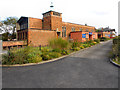
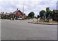
All Saints' Church, Stretford
The original All Saints' Church in Stretford was on nearby Cyprus Street. It was consecrated in 1885 but was completely destroyed when struck by an incediary bomb on 23 December 1940.
The "new" All Saints was situated on Barton Road, about a mile away from Cyprus Street, because of the original site's proximity to St Matthew's Stretford. The foundation stone was laid on 22 October 1955, with the new building being completed and consecrated on 16 March 1957.
Image: © David Dixon
Taken: 25 Sep 2011
0.09 miles
8
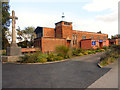
All Saints' Church and War Memorial, Stretford
The original All Saints' Church in Stretford was on nearby Cyprus Street. It was consecrated in 1885 but was completely destroyed when struck by an incediary bomb on 23 December 1940.
The "new" All Saints was situated on Barton Road, about a mile away from Cyprus Street, because of the original site's proximity to St Matthew's Stretford. The foundation stone was laid on 22 October 1955, with the new building being completed and consecrated on 16 March 1957.
Image: © David Dixon
Taken: 25 Sep 2011
0.09 miles