IMAGES TAKEN NEAR TO
Urmston Lane, MANCHESTER, M32 9DH
Introduction
This page details the photographs taken nearby to Urmston Lane, M32 9DH by members of the Geograph project.
The Geograph project started in 2005 with the aim of publishing, organising and preserving representative images for every square kilometre of Great Britain, Ireland and the Isle of Man.

There are currently over 7.5m images from over14,400 individuals and you can help contribute to the project by visiting https://www.geograph.org.uk
Image Map
Images are licensed for reuse under creativecommons.org/licenses/by-sa/2.0
Notes
- Clicking on the map will re-center to the selected point.
- The higher the marker number, the further away the image location is from the centre of the postcode.
Image Listing (12 Images Found)
Images are licensed for reuse under creativecommons.org/licenses/by-sa/2.0
Image
Details
Distance
2
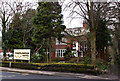
The Urmston Public House
The Urmston public house stands on Stretford Road, the main road between Stretford and Urmston, Manchester.
Image: © R Greenhalgh
Taken: 1 May 2007
0.13 miles
4
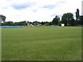
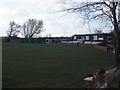
Cricket Ground
Stretford Cricket Ground looking north west towards the clubhouse.
Image: © David Newton
Taken: 9 Jun 2009
0.18 miles
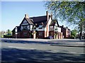
5
Stretford Cricket Club - Pavilion
The pavilion at Stretford CC. The club run three teams in the Lancashire County League.
Image: © BatAndBall
Taken: 25 Mar 2013
0.19 miles
6
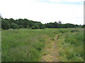
Footpath across uncultivated land
Looking east. Stretford Cricket Ground is behind me.
Image: © David Newton
Taken: 9 Jun 2009
0.20 miles
7
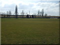
Stretford Cricket Club - Ground
Looking across Stretford CC's ground, "The Boundary" towards the M60.
Image: © BatAndBall
Taken: 25 Mar 2013
0.22 miles
8
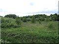
Coppice Land
Viewed looking west from the track leading to the Cricket Ground.
Image: © David Newton
Taken: 9 Jun 2009
0.22 miles
9
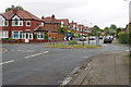
Roundabout on Bradfield Road
Bradfield Road is crossed by Barkway Road.
Image: © Bill Boaden
Taken: 9 May 2019
0.23 miles
10
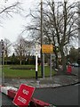
Stretford, fingerpost
A nice relic from times past; fingerpost at junction Urmston & Sandy Lanes, with ring finial "STRETFORD". In 1964, the Worboys Committee recommended that all road signs be standardised; Stretford UDC disappeared ten years later, anyway. Well maintained, even if this junction is currently closed.
Image: © Mike Faherty
Taken: 25 Jan 2009
0.25 miles