IMAGES TAKEN NEAR TO
Brunswick Street, MANCHESTER, M32 8NU
Introduction
This page details the photographs taken nearby to Brunswick Street, M32 8NU by members of the Geograph project.
The Geograph project started in 2005 with the aim of publishing, organising and preserving representative images for every square kilometre of Great Britain, Ireland and the Isle of Man.

There are currently over 7.5m images from over14,400 individuals and you can help contribute to the project by visiting https://www.geograph.org.uk
Image Map
Images are licensed for reuse under creativecommons.org/licenses/by-sa/2.0
Notes
- Clicking on the map will re-center to the selected point.
- The higher the marker number, the further away the image location is from the centre of the postcode.
Image Listing (79 Images Found)
Images are licensed for reuse under creativecommons.org/licenses/by-sa/2.0
Image
Details
Distance
1
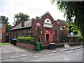
Salvation Army Church
Salvation Army Meadow Community Church, Brunswick St., Stretford.
Image: © David Newton
Taken: 26 Jun 2009
0.03 miles
3
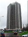
Towerblock in Stretford
On the junction of the A56 and Barton Road.
Image: © Eirian Evans
Taken: 3 Dec 2009
0.07 miles
4
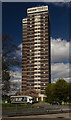
Stretford
Tower block in Stretford.
Image: © Peter McDermott
Taken: 22 Apr 2017
0.08 miles
5
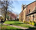
St Matthew's churchyard
The south side of St Matthew's church Image
Image: © Gerald England
Taken: 8 Apr 2017
0.11 miles
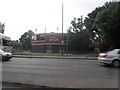
6
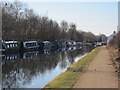
Canal users club
Well used stretch of the Bridgewater canal. The club building houses a bar. The view is looking towards Sale.
Image: © Paddy Griffin
Taken: 7 Mar 2010
0.12 miles
7
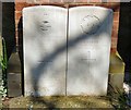
War graves in St Matthew's, Stretford
Buried in this churchyard are 748675 Flight Sergeant W.L.Leonard pilot with the Royal Air Force died 13th December 1941 aged 21. Also his brother Harry lost on mine laying operations 29.12.42 aged 20. See also https://www.twgpp.org/photograph/view/2126048
On the right: M/416524 Private S Farrar, Royal Army Service Corps 17th March 1919. See also https://www.twgpp.org/photograph/view/2126047
Image: © Gerald England
Taken: 8 Apr 2017
0.12 miles
8
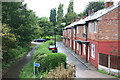
Hawthorn Road
Canalside houses in Trafford
Image: © Richard Croft
Taken: 10 Sep 2010
0.13 miles
9

St Matthew's, Stretford
There has been a church on this site since at least 1413. The present church dates from 1841 and was enlarged in the 1860s, 1906 and 1922. It is by W.Hayley for the Church Commissioners and is Grade II listed https://historicengland.org.uk/listing/the-list/list-entry/1356518
Church website: http://www.stretfordstmatthews.com/
Image: © Gerald England
Taken: 8 Apr 2017
0.13 miles
10
St Matthew's, Stretford
There has been a church on this site since at least 1413. The present church dates from 1841 and was enlarged in the 1860s, 1906 and 1922. It is by W.Hayley for the Church Commissioners and is Grade II listed https://historicengland.org.uk/listing/the-list/list-entry/1356518
Church website: http://www.stretfordstmatthews.com/
Image: © Gerald England
Taken: 16 Apr 2021
0.13 miles