IMAGES TAKEN NEAR TO
Nelson Street, MANCHESTER, M32 8LU
Introduction
This page details the photographs taken nearby to Nelson Street, M32 8LU by members of the Geograph project.
The Geograph project started in 2005 with the aim of publishing, organising and preserving representative images for every square kilometre of Great Britain, Ireland and the Isle of Man.

There are currently over 7.5m images from over14,400 individuals and you can help contribute to the project by visiting https://www.geograph.org.uk
Image Map
Images are licensed for reuse under creativecommons.org/licenses/by-sa/2.0
Notes
- Clicking on the map will re-center to the selected point.
- The higher the marker number, the further away the image location is from the centre of the postcode.
Image Listing (132 Images Found)
Images are licensed for reuse under creativecommons.org/licenses/by-sa/2.0
Image
Details
Distance
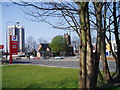
1
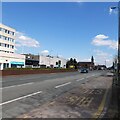
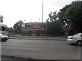
Chester Road
The A56 through Stretford.
Image: © Gerald England
Taken: 16 Apr 2021
0.04 miles
2
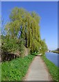
Willow Tree by the Bridgewater Canal
South of Stretford.
Image: © Gerald England
Taken: 8 Apr 2017
0.07 miles
4
St Matthew's, Stretford
There has been a church on this site since at least 1413. The present church dates from 1841 and was enlarged in the 1860s, 1906 and 1922. It is by W.Hayley for the Church Commissioners and is Grade II listed https://historicengland.org.uk/listing/the-list/list-entry/1356518
Church website: http://www.stretfordstmatthews.com/
Image: © Gerald England
Taken: 16 Apr 2021
0.08 miles
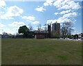
6
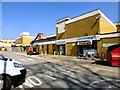
Stretford Mall
View from the car park at the rear. The entrance is next door to the Kingfisher cafe.
The mall opened in 1969 as an Arndale Centre. It was renamed Stretford Mall in 2003.
Image: © Gerald England
Taken: 8 Apr 2017
0.09 miles
7

St Matthew's, Stretford
There has been a church on this site since at least 1413. The present church dates from 1841 and was enlarged in the 1860s, 1906 and 1922. It is by W.Hayley for the Church Commissioners and is Grade II listed https://historicengland.org.uk/listing/the-list/list-entry/1356518
Church website: http://www.stretfordstmatthews.com/
Image: © Gerald England
Taken: 8 Apr 2017
0.09 miles
8
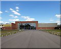
Stretford Mall
The mall opened in 1969 as an Arndale Centre. It was renamed Stretford Mall in 2003.
Image: © Gerald England
Taken: 16 Apr 2021
0.09 miles
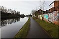
9
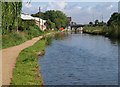
Bridgewater Canal approaching Edge Lane Bridge
In the centre ahead can be seen the red railings shown in Image The extra width of the canal apparent at this point is because there is a winding hole on the other side.
Image: © Derek Harper
Taken: 19 Aug 2010
0.09 miles
10
St Matthew's Church Stretford
The busy A56 is a major road running into Manchester. St Matthew's Church Stretford has remained the same whilst Stretford Mall has been built to the north, a block of flats to the south, and a garage opposite.
Image: © R Greenhalgh
Taken: 2 Apr 2007
0.10 miles