IMAGES TAKEN NEAR TO
Granby Road, MANCHESTER, M32 8JB
Introduction
This page details the photographs taken nearby to Granby Road, M32 8JB by members of the Geograph project.
The Geograph project started in 2005 with the aim of publishing, organising and preserving representative images for every square kilometre of Great Britain, Ireland and the Isle of Man.

There are currently over 7.5m images from over14,400 individuals and you can help contribute to the project by visiting https://www.geograph.org.uk
Image Map
Images are licensed for reuse under creativecommons.org/licenses/by-sa/2.0
Notes
- Clicking on the map will re-center to the selected point.
- The higher the marker number, the further away the image location is from the centre of the postcode.
Image Listing (19 Images Found)
Images are licensed for reuse under creativecommons.org/licenses/by-sa/2.0
Image
Details
Distance
2
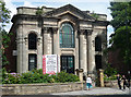
Former Union Baptist Chapel, Edge Lane, Stretford
Built in 1867. It has a fine attached portico of two pairs of Corinthian columns crowned by an open pediment. Perched above the frieze are two owls (Image]). Grade II listed.
It is now offices, Rylands Hall, named after the chapel's patron John Rylands.
Image: © Stephen Richards
Taken: 25 Jul 2011
0.09 miles
3
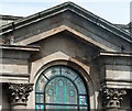
Detail of former Union Baptist Chapel, Edge Lane, Stretford
The two owls are a curious feature, and almost certainly not original.
Full view of the building here: Image
Image: © Stephen Richards
Taken: 25 Jul 2011
0.09 miles
4
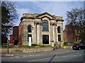
Converted Church on Edge Lane Stretford
Image: © R Greenhalgh
Taken: 2 Apr 2007
0.10 miles
5
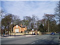
Entrance Lodge into Longford Park
The lodge into Longford Park is now a private house but was originally the lodge from Edge Lane into the grounds of Longford Hall.
Image: © R Greenhalgh
Taken: 2 Apr 2007
0.14 miles
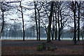
7
Mersey Valley Countryside
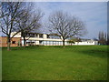
Open view looking north-east from Hawthorn Rd., Stretford Grammar School can just be seen in the background.
Image: © David Newton
Taken: 26 Jun 2009
0.20 miles
8
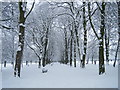
Longford Park Stretford
A snow scene to compare with photograph Image showing the same scene in April 2007.
Image: © R Greenhalgh
Taken: 5 Jan 2010
0.20 miles
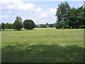
9
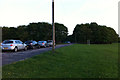
Turn Moss Playing Fields
The trees hide changing rooms and a car park, occupying the site and buildings of a wartime army camp (of which I have little information).
Image: © Phil Champion
Taken: 24 Apr 2011
0.21 miles
10
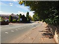
Edge Lane
Entering Stretford on the A5145.
Image: © Gerald England
Taken: 17 Sep 2016
0.21 miles