IMAGES TAKEN NEAR TO
Henshaw Street, MANCHESTER, M32 8BU
Introduction
This page details the photographs taken nearby to Henshaw Street, M32 8BU by members of the Geograph project.
The Geograph project started in 2005 with the aim of publishing, organising and preserving representative images for every square kilometre of Great Britain, Ireland and the Isle of Man.

There are currently over 7.5m images from over14,400 individuals and you can help contribute to the project by visiting https://www.geograph.org.uk
Image Map
Images are licensed for reuse under creativecommons.org/licenses/by-sa/2.0
Notes
- Clicking on the map will re-center to the selected point.
- The higher the marker number, the further away the image location is from the centre of the postcode.
Image Listing (33 Images Found)
Images are licensed for reuse under creativecommons.org/licenses/by-sa/2.0
Image
Details
Distance
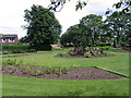
2
Victoria's Lawn
Victoria Park Stretford.
Image: © David Newton
Taken: 9 Jun 2009
0.14 miles
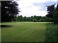
3
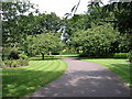
Victoria Park
Entrance to the park from Barton Rd.
Image: © David Newton
Taken: 9 Jun 2009
0.14 miles
4
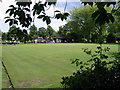
Game on
The bowling green, Victoria Park, Stretford.
Image: © David Newton
Taken: 9 Jun 2009
0.15 miles
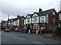
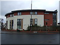
7
Chester Road
Buildings on Chester Road.
Image: © Peter McDermott
Taken: 22 Apr 2017
0.19 miles
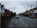
8
Kingsway, Stretford
The A5145 at Stretford.
Image: © Gerald England
Taken: 17 Sep 2016
0.19 miles
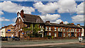
10
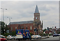
"For sale or long lease"
Formerly Stretford Public Hall
Image: © Ian Greig
Taken: 11 Jul 2014
0.20 miles