IMAGES TAKEN NEAR TO
Enriqueta Rylands Close, MANCHESTER, M32 0GX
Introduction
This page details the photographs taken nearby to Enriqueta Rylands Close, M32 0GX by members of the Geograph project.
The Geograph project started in 2005 with the aim of publishing, organising and preserving representative images for every square kilometre of Great Britain, Ireland and the Isle of Man.

There are currently over 7.5m images from over14,400 individuals and you can help contribute to the project by visiting https://www.geograph.org.uk
Image Map
Images are licensed for reuse under creativecommons.org/licenses/by-sa/2.0
Notes
- Clicking on the map will re-center to the selected point.
- The higher the marker number, the further away the image location is from the centre of the postcode.
Image Listing (44 Images Found)
Images are licensed for reuse under creativecommons.org/licenses/by-sa/2.0
Image
Details
Distance
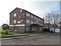
1

Novus
The Novus housing development at Gorse Hill on the former Itron site.
Image: © Peter McDermott
Taken: 13 Apr 2020
0.05 miles
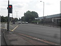
2
Talbot Court, Talbot Road, Gorse Hill
The nearest ground floor flat has in the past been a doctors' surgery. The single storey extension was built then to house the medical records.
Image: © Christine Johnstone
Taken: 15 Feb 2015
0.06 miles
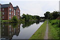
5
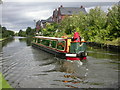
Gorse Hill, canal boat
Narrowboat "Tereen" from Bridgewater Marina, on the Bridgewater Canal; new housing in Longford Road in the background.
Image: © Mike Faherty
Taken: 31 Aug 2009
0.15 miles
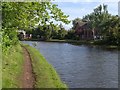
6
The Bridgewater Canal nearing Stretford
The canal is about to go under the A56, Chester Road.
Image: © Bill Boaden
Taken: 4 Sep 2010
0.16 miles
7

Bridgewater Canal
Graffiti on the Chester Road bridge over the Bridgewater Canal.
Image: © Peter McDermott
Taken: 5 May 2017
0.17 miles
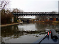
8
Bridgewater Canal near Stretford
The canal rounds a left bend, the sharpest for about 10 kilometres heading northeastwards. On the opposite bank is Longford Wharf, flats.
Image: © Derek Harper
Taken: 19 Aug 2010
0.17 miles
9
Bridgewater Canal: Pipe bridge
Longford Road bridge is seen further on.
Image: © Dr Neil Clifton
Taken: 29 Mar 2015
0.17 miles
10
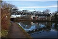
Pipe bridge over the Bridgewater Canal, Stretford
Image: © Ian S
Taken: 1 Mar 2022
0.17 miles