IMAGES TAKEN NEAR TO
Victoria Street, MANCHESTER, M3 1ST
Introduction
This page details the photographs taken nearby to Victoria Street, M3 1ST by members of the Geograph project.
The Geograph project started in 2005 with the aim of publishing, organising and preserving representative images for every square kilometre of Great Britain, Ireland and the Isle of Man.

There are currently over 7.5m images from over14,400 individuals and you can help contribute to the project by visiting https://www.geograph.org.uk
Image Map
Images are licensed for reuse under creativecommons.org/licenses/by-sa/2.0
Notes
- Clicking on the map will re-center to the selected point.
- The higher the marker number, the further away the image location is from the centre of the postcode.
Image Listing (2695 Images Found)
Images are licensed for reuse under creativecommons.org/licenses/by-sa/2.0
Image
Details
Distance
2
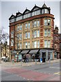
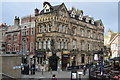
The Britannic Buildings, 42-44 Victoria Street, Manchester
Britannic Buildings, on Victoria Street, is attached to Image], around the corner on Cateaton Street. It was once occupied by The Britannic Assurance Company. That company started in Birmingham and began to spread across the UK in 1905. So presumably, if the building was built for them, it must date from around that time.
The five-storey, red brick and sandstone former commercial building has been redeveloped into four floors of apartments above a ground floor retail space currently occupied by Hanging Ditch Wine Merchants.
http://manchesterhistory.net/manchester/tours/tour4/area4page7a.html Manchester History Net
Image: © David Dixon
Taken: 18 Feb 2015
0.00 miles
3
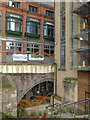
Manchester Cathedral Visitor Centre
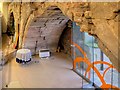
As part of the Millennium Quarter redevelopment the Cathedral used a narrow office building called Hanging Bridge Chambers to create a Visitors' Centre. The interesting part is the arch in the basement which can be seen in the photograph.
This arch is part of northern arch of Hanging Bridge (Image]), a mediæval bridge over a stream known as Hanging Ditch which ran from the River Irk to the River Irwell. The stream became badly polluted and in 1600 the Hanging Ditch was condemned as an unsanitary open sewer, and in the following years the ditch was culverted and the bridge buried and built over. The bridge was largely forgotten (although the area retained the name "Hanging Ditch") until uncovered during demolition work in the 1880s. Covered up during the Victorian expansion of Manchester, the bridge remained hidden until, more than 100 years later it was uncovered again, and following restoration work it went on display in 2002 as a part of Manchester Cathedral's newly built visitor centre.
From outside, the bridge is now largely hidden by modern buildings, but it can be seen from inside the basement of the Cathedral Visitor Centre, where it forms one side of the refectory. The bridge is listed as a Scheduled Ancient Monument.
http://news.bbc.co.uk/1/hi/uk/england/1717912.stm BBC News December 2001
Image: © David Dixon
Taken: 28 Mar 2013
0.00 miles
4
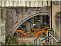
Hanging Bridge
This arch is part of the remnants of Hanging Bridge, a mediæval bridge over a stream known as Hanging Ditch which ran from the River Irk to the River Irwell. The bridge was a crossing point between the town of Manchester and the Cathedral (then a parish church). The structure seen today was built in 1421, replacing an earlier bridge.
During the 16th century, the stream became badly polluted and by 1600 the Hanging Ditch was condemned as an unsanitary open sewer. Over the following years the ditch was filled in and the bridge buried and built over. The bridge was largely forgotten (although the area retained the name "Hanging Ditch") until uncovered during demolition work in the 1880s. Covered up during the Victorian expansion of Manchester, the bridge remained hidden until, more than 100 years later, it was uncovered again, and following restoration work it went on display in 2002 as a part of Manchester Cathedral's newly built visitor centre.
From the outside, the bridge is now largely hidden by modern buildings (see Image] for a wider view), but it can be seen from inside the basement of the Cathedral Visitor Centre, where it forms one side of the refectory. The bridge, One of Manchester's oldest structures, is listed as a Scheduled Ancient Monument.
http://news.bbc.co.uk/1/hi/uk/england/1717912.stm BBC News December 2001
Image: © David Dixon
Taken: 28 Mar 2013
0.00 miles
5
Hanging Bridge, Manchester Cathedral Visitor Centre
Part of the remnants of Hanging Bridge, a mediæval bridge over a stream known as Hanging Ditch which ran from the River Irk to the River Irwell. The bridge was a crossing point between the town of Manchester and the Cathedral (then a parish church). The structure seen today was built in 1421, replacing an earlier bridge.
During the 16th century, the stream became badly polluted and by 1600 the Hanging Ditch was condemned as an unsanitary open sewer. Over the following years the ditch was filled in and the bridge buried and built over. The bridge was largely forgotten (although the area retained the name "Hanging Ditch") until uncovered during demolition work in the 1880s. Covered up during the Victorian expansion of Manchester, the bridge remained hidden again until, more than 100 years later, it was uncovered again, and following restoration work it went on display in 2002 as a part of Manchester Cathedral's newly built visitor centre.
From the outside, the bridge is now largely hidden by modern buildings, but it can be seen from inside the basement of the Cathedral Visitor Centre, where it forms one side of the refectory. The bridge, one of Manchester's oldest structures, is listed as a Scheduled Ancient Monument.
See Image] and Image] for exterior views.
Image: © David Dixon
Taken: 25 Feb 2014
0.00 miles
6
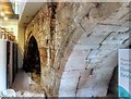
Hanging Bridge, Manchester
Part of the remnants of Hanging Bridge, a mediæval bridge over a stream known as Hanging Ditch which ran from the River Irk to the River Irwell. The bridge was a crossing point between the town of Manchester and the Cathedral (then a parish church). The structure seen today was built in 1421, replacing an earlier bridge.
During the 16th century, the stream became badly polluted and by 1600 the Hanging Ditch was condemned as an unsanitary open sewer. Over the following years the ditch was filled in and the bridge buried and built over. The bridge was largely forgotten (although the area retained the name "Hanging Ditch") until uncovered during demolition work in the 1880s. Covered up during the Victorian expansion of Manchester, the bridge remained hidden again until, more than 100 years later, it was uncovered again, and following restoration work it went on display in 2002 as a part of Manchester Cathedral's newly built visitor centre.
From the outside, the bridge is now largely hidden by modern buildings, but it can be seen from inside the basement of the Cathedral Visitor Centre, where it forms one side of the refectory. The bridge, one of Manchester's oldest structures, is listed as a Scheduled Ancient Monument.
See Image] and Image] for exterior views.
Image: © David Dixon
Taken: 7 Jul 2015
0.00 miles
7
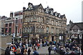
The Mitre
Grade II listed. http://www.britishlistedbuildings.co.uk/en-387971-mitre-hotel-
Image: © N Chadwick
Taken: 20 Dec 2014
0.00 miles
10
Mynshull's House, Cateaton Street, Manchester
Image: © Alexander P Kapp
Taken: 3 Jan 2012
0.01 miles