IMAGES TAKEN NEAR TO
New Bridge Street, MANCHESTER, M3 1NQ
Introduction
This page details the photographs taken nearby to New Bridge Street, M3 1NQ by members of the Geograph project.
The Geograph project started in 2005 with the aim of publishing, organising and preserving representative images for every square kilometre of Great Britain, Ireland and the Isle of Man.

There are currently over 7.5m images from over14,400 individuals and you can help contribute to the project by visiting https://www.geograph.org.uk
Image Map (1358 Images)


Leaflet Map data © OpenStreetMap
Images are licensed for reuse under creativecommons.org/licenses/by-sa/2.0
Notes
- Clicking on the map will re-center to the selected point.
- The higher the marker number, the further away the image location is from the centre of the postcode.
Image Listing (1358 Images Found)
Images are licensed for reuse under creativecommons.org/licenses/by-sa/2.0
Image
Details
Distance
1
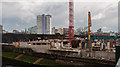
Building Site
Building site, part of the Greengate Development, alongside the River Irwell.
Image: © Peter McDermott
Taken: 19 Jul 2014
0.01 miles
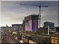
3
New Development next to the Irwell at Greengate
Image: © David Dixon
Taken: 29 Jan 2016
0.02 miles
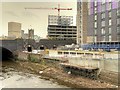
5
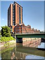
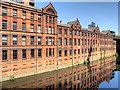
River Irwell, New Bridge Street
The red-brick building behind the bridge is the grade II-listed former parcel sorting office, now converted for residential use. The tower block is called the "Tempus Tower"; it appears to be linked to the former sorting office.
Image: © David Dixon
Taken: 11 Jun 2015
0.03 miles
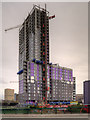
7
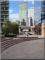
Urban Regeneration at Greengate
New, 21st century, high rise buildings behind the railway arch on Greengate.
Image: © David Dixon
Taken: 5 Sep 2018
0.04 miles
8
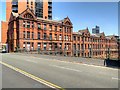
New Bridge Street, Manchester Parcel Post Office
The south-west elevation of the former Manchester parcel sorting office, as seen from New Bridge Street.
Image: © David Dixon
Taken: 11 Jun 2015
0.04 miles
9

Manchester Exchange Station
View eastwards on Platform 3, towards Victoria Station and Yorkshire destinations. Exchange was the ex-London & North Western Station, adjoining the ex-Lancashire & Yorkshire Victoria Station and connected to it by a very long extension of Platform 11 of the latter. This was a Summer Saturday, when the two stations were particularly busy; moreover in 1960 they were also handling much of the Piccadilly Station's traffic while the latter was being rebuilt for electrification. The train on the left (Platform 4), headed by a BR Standard Class 5 4-6-0, is the 15.15 to Huddersfield and Bradford; the train entering, with a 'Jubilee' class 4-6-0, was heading west (or north). Exchange Station was half destroyed in the Blitz in December 1940 and was closed in May 1969.
Image: © Ben Brooksbank
Taken: 3 Sep 1960
0.04 miles
10
River Irwell, Manchester Parcel Sorting Office
A view of the south-west elevation of the former Manchester parcel sorting office on the bank of the River Irwell.
Image: © David Dixon
Taken: 11 Jun 2015
0.04 miles