IMAGES TAKEN NEAR TO
Elderflower Way, M31 4TA
Introduction
This page details the photographs taken nearby to Elderflower Way, M31 4TA by members of the Geograph project.
The Geograph project started in 2005 with the aim of publishing, organising and preserving representative images for every square kilometre of Great Britain, Ireland and the Isle of Man.

There are currently over 7.5m images from over14,400 individuals and you can help contribute to the project by visiting https://www.geograph.org.uk
Image Map
Images are licensed for reuse under creativecommons.org/licenses/by-sa/2.0
Notes
- Clicking on the map will re-center to the selected point.
- The higher the marker number, the further away the image location is from the centre of the postcode.
Image Listing (19 Images Found)
Images are licensed for reuse under creativecommons.org/licenses/by-sa/2.0
Image
Details
Distance
2
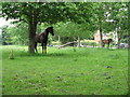
Partington - Horses Grazing
Horses have been corralled on the open space adjacent to the A6144 and Oak Road.
Image: © Peter Whatley
Taken: 3 Jun 2009
0.02 miles
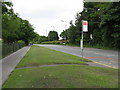
4
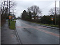
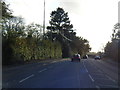
Warburton Lane (A6144)
Heading north into Partington.
Image: © JThomas
Taken: 9 Mar 2013
0.09 miles
5
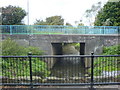
Red Brook
Taken from the "old road" bridge looking downstream. Red Brook flows under the bridge carrying Warburton Lane (A6144).
Image: © Keith Williamson
Taken: 29 Sep 2007
0.10 miles
6
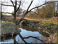
Red Brook, Partington
Walking along the "Redbrook Wildlife Trail", behind the houses of Oak Road.
Image: © David Dixon
Taken: 3 Feb 2012
0.10 miles
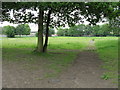
7

Redbrook Wildlife Trail
The redbrook trail is along the bank of Red Brook, to the south west of Partington Village. The "wildlife" refers to insects, birds, butterflies etc; there are no lions or tigers!
Image: © David Dixon
Taken: 3 Feb 2012
0.11 miles
10
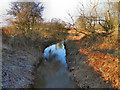
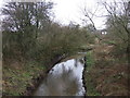
Red Brook
A stream to the south west of Partington. Viewed from the bridge at Warburton Lane.
Image: © David Dixon
Taken: 3 Feb 2012
0.12 miles