IMAGES TAKEN NEAR TO
Lock Lane, MANCHESTER, M31 4QE
Introduction
This page details the photographs taken nearby to Lock Lane, M31 4QE by members of the Geograph project.
The Geograph project started in 2005 with the aim of publishing, organising and preserving representative images for every square kilometre of Great Britain, Ireland and the Isle of Man.

There are currently over 7.5m images from over14,400 individuals and you can help contribute to the project by visiting https://www.geograph.org.uk
Image Map
Images are licensed for reuse under creativecommons.org/licenses/by-sa/2.0
Notes
- Clicking on the map will re-center to the selected point.
- The higher the marker number, the further away the image location is from the centre of the postcode.
Image Listing (22 Images Found)
Images are licensed for reuse under creativecommons.org/licenses/by-sa/2.0
Image
Details
Distance
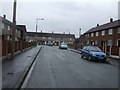
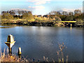
1
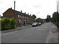
Partington - Lock Lane
Part of an extensive and decidedly dodgy council estate. Geograph hunters should exercise caution.
Image: © Peter Whatley
Taken: 3 Jun 2009
0.04 miles
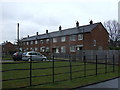
2
Partington - Ash Road
Part of an extensive and decidedly dodgy council estate. Geograph hunters should exercise caution.
Image: © Peter Whatley
Taken: 3 Jun 2009
0.05 miles
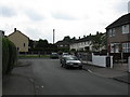
5
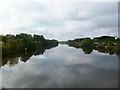
Partington, Manchester Ship Canal
With part of the tar distillery at Cadishead on the right.
Image: © Mike Faherty
Taken: 18 Sep 2011
0.10 miles
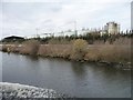
7

Manchester Ship Canal
The Manchester Ship Canal, west of Cadishead Viaduct.
Image: © David Dixon
Taken: 18 Mar 2011
0.11 miles
8
Manchester Ship Canal
The Manchester Ship Canal, west of the Cadishead Viaduct.
Image: © David Dixon
Taken: 18 Mar 2011
0.11 miles

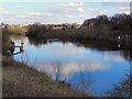
10
Manchester Ship Canal beacon 344
On the north bank, by Cadishead tar distillery.
Image: © Christine Johnstone
Taken: 13 Apr 2013
0.13 miles