IMAGES TAKEN NEAR TO
Meadow Walk, MANCHESTER, M31 4PB
Introduction
This page details the photographs taken nearby to Meadow Walk, M31 4PB by members of the Geograph project.
The Geograph project started in 2005 with the aim of publishing, organising and preserving representative images for every square kilometre of Great Britain, Ireland and the Isle of Man.

There are currently over 7.5m images from over14,400 individuals and you can help contribute to the project by visiting https://www.geograph.org.uk
Image Map
Images are licensed for reuse under creativecommons.org/licenses/by-sa/2.0
Notes
- Clicking on the map will re-center to the selected point.
- The higher the marker number, the further away the image location is from the centre of the postcode.
Image Listing (10 Images Found)
Images are licensed for reuse under creativecommons.org/licenses/by-sa/2.0
Image
Details
Distance
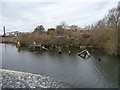
7
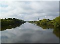
Cadishead, Manchester Ship Canal
With a timberyard and chemical plant in the distance.
Image: © Mike Faherty
Taken: 18 Sep 2011
0.19 miles
9
Manchester Ship Canal navigation beacon
On the north bank, west of Hayes Green.
Image: © Christine Johnstone
Taken: 13 Apr 2013
0.25 miles
10
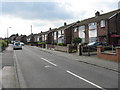
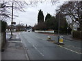
Manchester New Road
The A6144 through Partington.
Image: © Gerald England
Taken: 16 Apr 2021
0.25 miles