IMAGES TAKEN NEAR TO
Lock Lane, MANCHESTER, M31 4BS
Introduction
This page details the photographs taken nearby to Lock Lane, M31 4BS by members of the Geograph project.
The Geograph project started in 2005 with the aim of publishing, organising and preserving representative images for every square kilometre of Great Britain, Ireland and the Isle of Man.

There are currently over 7.5m images from over14,400 individuals and you can help contribute to the project by visiting https://www.geograph.org.uk
Image Map
Images are licensed for reuse under creativecommons.org/licenses/by-sa/2.0
Notes
- Clicking on the map will re-center to the selected point.
- The higher the marker number, the further away the image location is from the centre of the postcode.
Image Listing (16 Images Found)
Images are licensed for reuse under creativecommons.org/licenses/by-sa/2.0
Image
Details
Distance
1
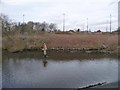
Walker on the Manchester Ship Canal's north bank
Heading towards Glaze Brook, from Hollins Green.
Image: © Christine Johnstone
Taken: 13 Apr 2013
0.08 miles
2
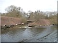
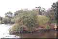
Glaze Brook entering the Manchester Ship Canal
For the reverse view, see Image Local authority boundaries run down the middle of both the canal and the brook.
Image: © Christine Johnstone
Taken: 13 Apr 2013
0.09 miles
3
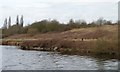
Sandstone, the Manchester Ship Canal's north bank
The canal follows the canalised River Mersey here, so sometimes the banks are 'natural'.
Image: © Christine Johnstone
Taken: 13 Apr 2013
0.09 miles
4
Glaze Brook enters the Manchester Ship Canal
Here, on the border between Cheshire and Salford, the Manchester Ship Canal receives the waters of Glaze Brook (also known as the River Glaze). The Glaze drains a substantial area of mossland hereabouts and was the boundary between the ancient Lancashire Hundreds of West Derby and Salford.This latter fact is recorded on the wall of a bridge near here that carries the A57 road over the Glaze, but as the wall is made of sandstone the lettering is wearing away.This part of the Ship Canal is a canalised section of the River Mersey. The Mersey joined the canal a little way upstream of this point (to the left) and will leave the canal a little further downstream, close to where the River Bollin joins the canal. Taken from SJ703912
Image: © Keith Williamson
Taken: 3 Aug 2005
0.12 miles
5
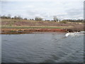
Sandstone canal bank
Small promontory on the south bank of the Manchester Ship Canal.
Image: © Trevor Harris
Taken: 2 Sep 2012
0.18 miles
6
Manchester Ship Canal beacon 342
On the north bank. Image has more details about the distant sculpture on the A57 roundabout.
Image: © Christine Johnstone
Taken: 13 Apr 2013
0.19 miles
7
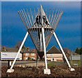
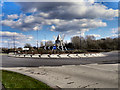
Marge and Steel Roundabout
The design is based on an idea developed by artists Marcela Livingstone and Liam Curlin with local people. It all came about by asking the views of local people. The children wanted a modern super hero theme and adults talked about the Steel and Margarine works that used to be here. Retired workers told them about the tea dances they enjoyed. An idea was developed to portray the dance of these two industries which forged people's lives together in Irlam & Cadishead.
Image: © David Taylor
Taken: 8 Feb 2008
0.21 miles
8
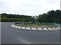
Roundabout on the A57 at Cadishead
Artwork on roundabout at junction with Liverpool Road
Image: © Raymond Knapman
Taken: 5 Aug 2014
0.21 miles
9
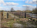
Path By The Ship Canal
This path runs parallel to, and between, the Manchester Ship Canal and Image
Image: © David Dixon
Taken: 18 Mar 2011
0.21 miles
10
Traffic Island, Cadishead Way
For details, see Image]
Image: © David Dixon
Taken: 18 Mar 2011
0.21 miles