IMAGES TAKEN NEAR TO
Manchester Road, MANCHESTER, M31 4BD
Introduction
This page details the photographs taken nearby to Manchester Road, M31 4BD by members of the Geograph project.
The Geograph project started in 2005 with the aim of publishing, organising and preserving representative images for every square kilometre of Great Britain, Ireland and the Isle of Man.

There are currently over 7.5m images from over14,400 individuals and you can help contribute to the project by visiting https://www.geograph.org.uk
Image Map
Images are licensed for reuse under creativecommons.org/licenses/by-sa/2.0
Notes
- Clicking on the map will re-center to the selected point.
- The higher the marker number, the further away the image location is from the centre of the postcode.
Image Listing (25 Images Found)
Images are licensed for reuse under creativecommons.org/licenses/by-sa/2.0
Image
Details
Distance
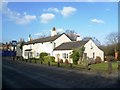
2
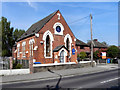
The Old Chapel, Carrington
The old chapel on Manchester Road in Carrington, is now used by a design company and as a recording studio.
Image: © David Dixon
Taken: 20 Apr 2011
0.03 miles
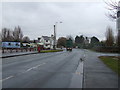
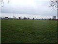
4
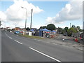
Car Boot Sale, Manchester Road, Carrington
Image: © Anthony Parkes
Taken: 30 May 2010
0.04 miles
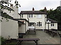
7
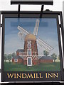
The Windmill Inn
A Sam Smith's public house in Carrington.
Image: © Ian S
Taken: 2 Oct 2012
0.09 miles
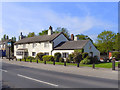
8
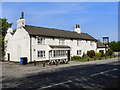
The Windmill Inn, Carrington
The Windmill Inn, on Manchester Road in Carrington village.
Image: © David Dixon
Taken: 20 Apr 2011
0.09 miles
9
The Windmill Inn
The Windmill Inn, on Manchester Road in Carrington village.
Image: © David Dixon
Taken: 20 Apr 2011
0.09 miles
10
The Windmill Inn
A Sam Smith's public house in Carrington.
Image: © Ian S
Taken: 2 Oct 2012
0.09 miles