IMAGES TAKEN NEAR TO
Cavendish Road, MANCHESTER, M30 9EE
Introduction
This page details the photographs taken nearby to Cavendish Road, M30 9EE by members of the Geograph project.
The Geograph project started in 2005 with the aim of publishing, organising and preserving representative images for every square kilometre of Great Britain, Ireland and the Isle of Man.

There are currently over 7.5m images from over14,400 individuals and you can help contribute to the project by visiting https://www.geograph.org.uk
Image Map
Images are licensed for reuse under creativecommons.org/licenses/by-sa/2.0
Notes
- Clicking on the map will re-center to the selected point.
- The higher the marker number, the further away the image location is from the centre of the postcode.
Image Listing (15 Images Found)
Images are licensed for reuse under creativecommons.org/licenses/by-sa/2.0
Image
Details
Distance
1
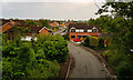
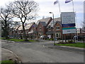
Greenwood Place, Ellesmere Park, Eccles
New housing development
Image: © Alexander P Kapp
Taken: 15 Aug 2007
0.07 miles
2
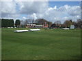
Monton & Weaste Cricket Club
Monton & Weaste CC run two teams in the Pennine Cricket League and a 3rd XI in the Greater Manchester Cricket League Sunday Division (West).
Image: © BatAndBall
Taken: 11 Apr 2015
0.10 miles
3
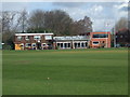
Monton & Weaste Cricket Club - Pavilion
The pavilion at Monton & Weaste CC's Welbeck Road ground.
Image: © BatAndBall
Taken: 11 Apr 2015
0.11 miles
4
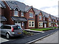
New Housing
"Greenwood" a new development on the site of a former special school, also known as Greenwood, in Ellesmere Park, Eccles
Image: © Keith Williamson
Taken: 24 Mar 2007
0.13 miles
5
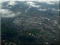
Swinton and Pendlebury from the air
Ellesmere park is in the foreground, Swinton is in the left, Pendlebury on the right.
Image: © Thomas Nugent
Taken: 10 Nov 2014
0.13 miles
6
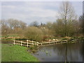
The Three Sisters
The Three Sisters nature reserve off Rutland Road, Ellesmere Park. This area contains three ponds which seem to have merged. It is a designated Site of Biological Interest and is thought to contain the longest surviving section of Roman Road (about 100m long) in the Greater Manchester area. The structure crossing the pond is a derelict boardwalk.
Image: © Keith Williamson
Taken: 24 Mar 2007
0.13 miles
7
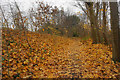
Leaf-strewn path up to the railway route
The sycamore leaves have almost entirely fallen now. The path is a link between Bradford Road and the former railway route which crosses it.
Image: © Bill Boaden
Taken: 30 Nov 2016
0.15 miles
8
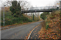
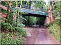
Bridge over Bradford Road
A railway formerly crossed the road here, but it is now just a footpath.
Image: © Bill Boaden
Taken: 30 Nov 2016
0.15 miles