IMAGES TAKEN NEAR TO
Wain Close, MANCHESTER, M30 8ND
Introduction
This page details the photographs taken nearby to Wain Close, M30 8ND by members of the Geograph project.
The Geograph project started in 2005 with the aim of publishing, organising and preserving representative images for every square kilometre of Great Britain, Ireland and the Isle of Man.

There are currently over 7.5m images from over14,400 individuals and you can help contribute to the project by visiting https://www.geograph.org.uk
Image Map
Images are licensed for reuse under creativecommons.org/licenses/by-sa/2.0
Notes
- Clicking on the map will re-center to the selected point.
- The higher the marker number, the further away the image location is from the centre of the postcode.
Image Listing (31 Images Found)
Images are licensed for reuse under creativecommons.org/licenses/by-sa/2.0
Image
Details
Distance
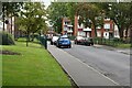
1
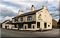
The Jolly Carter
The Jolly Carter public house.
Image: © Peter McDermott
Taken: 21 Jul 2019
0.03 miles
8
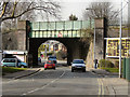
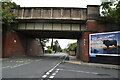
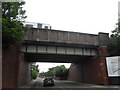
Worsley Road Railway Bridge
The Railway bridge at Worsley Road, between Winton and Patricroft.
Image: © David Dixon
Taken: 8 Mar 2011
0.13 miles