IMAGES TAKEN NEAR TO
Walker Green, MANCHESTER, M30 8LG
Introduction
This page details the photographs taken nearby to Walker Green, M30 8LG by members of the Geograph project.
The Geograph project started in 2005 with the aim of publishing, organising and preserving representative images for every square kilometre of Great Britain, Ireland and the Isle of Man.

There are currently over 7.5m images from over14,400 individuals and you can help contribute to the project by visiting https://www.geograph.org.uk
Image Map
Images are licensed for reuse under creativecommons.org/licenses/by-sa/2.0
Notes
- Clicking on the map will re-center to the selected point.
- The higher the marker number, the further away the image location is from the centre of the postcode.
Image Listing (6 Images Found)
Images are licensed for reuse under creativecommons.org/licenses/by-sa/2.0
Image
Details
Distance
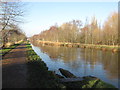
3
Bridgewater Canal
At a narrowed section where the banks of the canal are enforced with metal piles
Image: © Kevin Waterhouse
Taken: 6 Jun 2023
0.14 miles
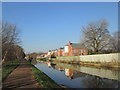
4
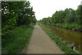
Bridgewater Canal & Cycle Path towards Worsley
Image: © Anthony Parkes
Taken: 20 May 2010
0.18 miles
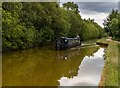
5
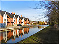
Bridgewater Canal
Modern housing at the side of The Bridgewater Canal, just east of Worsley.
Image: © David Dixon
Taken: 24 Feb 2011
0.22 miles