IMAGES TAKEN NEAR TO
Cleavley Street, MANCHESTER, M30 8EB
Introduction
This page details the photographs taken nearby to Cleavley Street, M30 8EB by members of the Geograph project.
The Geograph project started in 2005 with the aim of publishing, organising and preserving representative images for every square kilometre of Great Britain, Ireland and the Isle of Man.

There are currently over 7.5m images from over14,400 individuals and you can help contribute to the project by visiting https://www.geograph.org.uk
Image Map
Images are licensed for reuse under creativecommons.org/licenses/by-sa/2.0
Notes
- Clicking on the map will re-center to the selected point.
- The higher the marker number, the further away the image location is from the centre of the postcode.
Image Listing (19 Images Found)
Images are licensed for reuse under creativecommons.org/licenses/by-sa/2.0
Image
Details
Distance
2
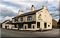
The Jolly Carter
The Jolly Carter public house.
Image: © Peter McDermott
Taken: 21 Jul 2019
0.16 miles
3
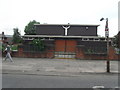
Winton Community Library
At the corner of Worsley Road and Old Parrin Lane. http://www.salford.gov.uk/wintonlibrary.htm
Image: © Mike Faherty
Taken: 13 Jan 2011
0.18 miles
4
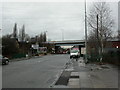
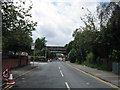
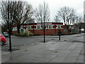
Winton, motorway bridge
Taking M602 over Worsley Road (B5211).
Image: © Mike Faherty
Taken: 13 Jan 2011
0.19 miles