IMAGES TAKEN NEAR TO
Stableford Avenue, MANCHESTER, M30 8AP
Introduction
This page details the photographs taken nearby to Stableford Avenue, M30 8AP by members of the Geograph project.
The Geograph project started in 2005 with the aim of publishing, organising and preserving representative images for every square kilometre of Great Britain, Ireland and the Isle of Man.

There are currently over 7.5m images from over14,400 individuals and you can help contribute to the project by visiting https://www.geograph.org.uk
Image Map
Images are licensed for reuse under creativecommons.org/licenses/by-sa/2.0
Notes
- Clicking on the map will re-center to the selected point.
- The higher the marker number, the further away the image location is from the centre of the postcode.
Image Listing (38 Images Found)
Images are licensed for reuse under creativecommons.org/licenses/by-sa/2.0
Image
Details
Distance
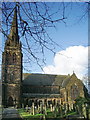
2

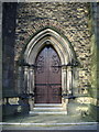
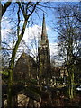
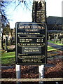
Monton Unitarian Church
The first Protestant church on this site was built in 1668. The present building dates from 1875.
Image: © philandju
Taken: 9 Apr 2013
0.03 miles
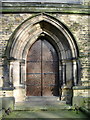
6
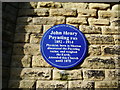
Unitarian Church, Monton, Blue plaque
To be found on the south side of the church http://en.wikipedia.org/wiki/John_Henry_Poynting
Image: © Alexander P Kapp
Taken: 5 Feb 2008
0.03 miles
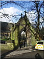
9
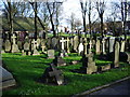
Unitarian Church, Monton, Graveyard
Image: © Alexander P Kapp
Taken: 5 Feb 2008
0.05 miles
10
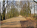
Roe Green Loopline, Monton Green
The former Roe Green railway line was closed in the 1960s. It has recently been made into a long distance trail ("the loopline"). This is at, or near to the site of the former Monton Green Railway Station>
Image: © David Dixon
Taken: 8 Mar 2011
0.05 miles