IMAGES TAKEN NEAR TO
Liverpool Road, MANCHESTER, M30 7RX
Introduction
This page details the photographs taken nearby to Liverpool Road, M30 7RX by members of the Geograph project.
The Geograph project started in 2005 with the aim of publishing, organising and preserving representative images for every square kilometre of Great Britain, Ireland and the Isle of Man.

There are currently over 7.5m images from over14,400 individuals and you can help contribute to the project by visiting https://www.geograph.org.uk
Image Map
Images are licensed for reuse under creativecommons.org/licenses/by-sa/2.0
Notes
- Clicking on the map will re-center to the selected point.
- The higher the marker number, the further away the image location is from the centre of the postcode.
Image Listing (23 Images Found)
Images are licensed for reuse under creativecommons.org/licenses/by-sa/2.0
Image
Details
Distance
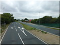
1
Cycle Path - A57 Liverpool Road, Irlam
Image: © Anthony Parkes
Taken: 6 Jun 2010
0.01 miles
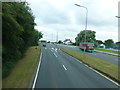
2
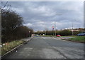
Liverpool Road at entrance to City Airport
Image: © Raymond Knapman
Taken: 5 Aug 2014
0.07 miles
3
Lay-by
End of the old A57, now used as a lay-by, where it joins the A57 dual carriageway
Image: © Alexander P Kapp
Taken: 26 Feb 2008
0.10 miles
4
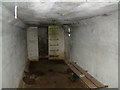
Air Raid Shelter
Air raid shelter by Barton Aerodrome / City Airport.
Image: © Phill
Taken: 15 Mar 2003
0.10 miles
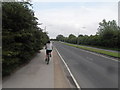
5
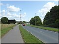
Liverpool Road
Heading towards the M60 motorway along the boundary of Barton Aerodrome.
Image: © Kevin Waterhouse
Taken: 20 Aug 2024
0.14 miles
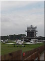
6
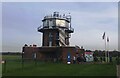
Control Tower at Manchester Barton Aerodrome
Image: © Anthony Parkes
Taken: 23 Oct 2023
0.17 miles
7
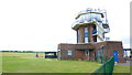
City Airport Manchester Control Tower
Image: © Richard Cooke
Taken: 17 Jun 2018
0.17 miles
8

Manchester Heliport
The Eurocopter EC135T2 of the North West Air Ambulance service.
Image: © Peter McDermott
Taken: 14 Jun 2017
0.18 miles