IMAGES TAKEN NEAR TO
Barton Moss, MANCHESTER, M30 7RW
Introduction
This page details the photographs taken nearby to Barton Moss, M30 7RW by members of the Geograph project.
The Geograph project started in 2005 with the aim of publishing, organising and preserving representative images for every square kilometre of Great Britain, Ireland and the Isle of Man.

There are currently over 7.5m images from over14,400 individuals and you can help contribute to the project by visiting https://www.geograph.org.uk
Image Map
Images are licensed for reuse under creativecommons.org/licenses/by-sa/2.0
Notes
- Clicking on the map will re-center to the selected point.
- The higher the marker number, the further away the image location is from the centre of the postcode.
Image Listing (5 Images Found)
Images are licensed for reuse under creativecommons.org/licenses/by-sa/2.0
Image
Details
Distance
2
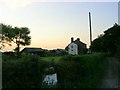
Farm on Chat Moss
Birch Farm on Chat Moss near Irlam, Manchester. Taken from SJ72209735 looking north.
Image: © Keith Williamson
Taken: 6 Sep 2005
0.06 miles
3
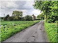
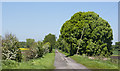
Road on Chat Moss
The road linking Twelve Yards Road and Birch Farm on Chat Moss. Looking south. SJ72209735
Image: © Keith Williamson
Taken: 6 Sep 2005
0.06 miles
4
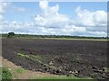
Tilled land on Barton Moss
Land near Birch Farm
Image: © Kevin Waterhouse
Taken: 20 Aug 2024
0.20 miles
5
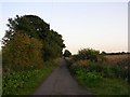
Fiddlers Lane across Chat Moss
Image: © Ian Greig
Taken: 25 May 2012
0.23 miles