IMAGES TAKEN NEAR TO
Buckthorn Lane, MANCHESTER, M30 7QD
Introduction
This page details the photographs taken nearby to Buckthorn Lane, M30 7QD by members of the Geograph project.
The Geograph project started in 2005 with the aim of publishing, organising and preserving representative images for every square kilometre of Great Britain, Ireland and the Isle of Man.

There are currently over 7.5m images from over14,400 individuals and you can help contribute to the project by visiting https://www.geograph.org.uk
Image Map
Images are licensed for reuse under creativecommons.org/licenses/by-sa/2.0
Notes
- Clicking on the map will re-center to the selected point.
- The higher the marker number, the further away the image location is from the centre of the postcode.
Image Listing (24 Images Found)
Images are licensed for reuse under creativecommons.org/licenses/by-sa/2.0
Image
Details
Distance
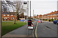
1
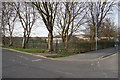
Trees screening Barton Moss Primary School
This is right on the edge of the Greater Manchester conurbation.
Image: © Bill Boaden
Taken: 5 Apr 2018
0.02 miles
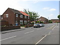
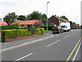
5
Bus stop and roadworks on Northfleet Road
The bus stop is just outside Salford City Academy.
Image: © Bill Boaden
Taken: 5 Apr 2018
0.12 miles
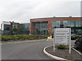
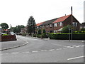
6
Salford City Academy
As seen from Northfleet Road.
Image: © Bill Boaden
Taken: 5 Apr 2018
0.12 miles
9
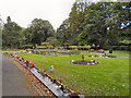
Garden of Remembrance, Peel Green Cemetery and Crematorium
Image: © David Dixon
Taken: 13 Sep 2012
0.13 miles
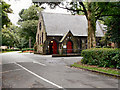
10
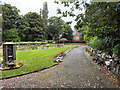
Peel Green Garden of Remembrance
The Garden of Remembrance outside the Peel Green Crematorium chapel.
Image: © David Dixon
Taken: 13 Sep 2012
0.13 miles